Search This Blog

Tuesday, December 27, 2022

Tom Thomson's After the Sleet Storm, 1916

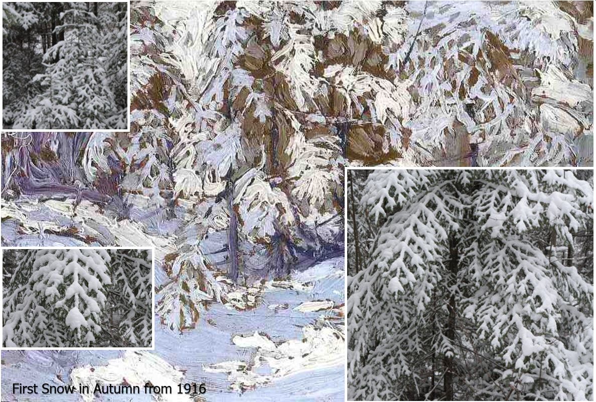
This is Tom’s “record” of freezing rain. It may not be a skyscape since the horizon is near the top third of the panel but the art is certainly all about the impacts of weather. Thomson painted "After the Sleet Storm" in his Shack Studio during the winter of 1915-16. It is unknown when Tom made the sketches in support of this decorative studio work but they were sufficiently representative in order to capture the reality of the event.  
After the Sleet Storm
Alternate title: Sleet Storm in the Cedar Bush Winter 1915–16
Oil on canvas 16 1/8 x 22 3/16 in. (40.9 x 56.3 cm)

The impacts of freezing rain can be quite severe.  Any coating of ice on surfaces makes travel extremely hazardous. Freezing rain typically lasts less than two hours but in those rare, extended events, the impacts can be severely extreme. I worked during the lead-up and duration of the Ice Storm of 1998 which has been called "The Worst Natural Disaster in Canadian History". Meteorology could accurately predict the occurrence but not prevent the impacts. 

The Back-lit Singleton Forest illustrates
the shimmering ice accumulations  similar 
to those that  Tom witnessed
Tom was certainly looking south when he composed the sketches.  Plein air artists rarely look toward the light anyway for the following reasons:

  • the bright sunlight is damaging to your eyes
  • the visible side of a backlit subject must be in shadow and lacking in colour and interest
  • the painting surface and pallet are probably also in shadow making the colours difficult to discern

Perhaps this is why Tom based this studio work on quick sketches which he saved for some winter day when painting in front of the wood stove would be easier on the eyes and the body. I must also confess to doing the same thing in my Studio Shack more and more now. I am not forty years old anymore...

In any event, Tom was looking southward. The forests on the distant hillsides were all very dark in Tom’s painting. Tom was looking at the shadowed sides of those wintry slopes. The sunlight originated from the far side of the hills and Tom was certainly looking southerly. 


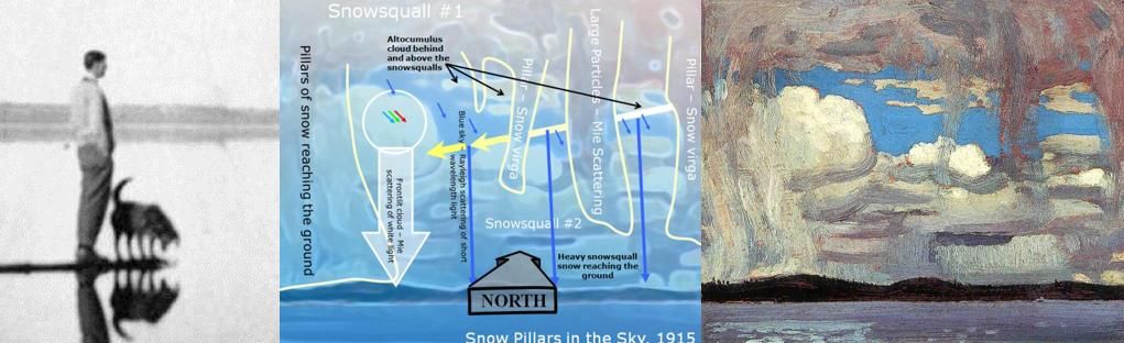
The accompanying graphic depicts the science of freezing rain following a snowflake from the top of the clouds through an above-freezing layer. The layer of warm air to the right of the white freezing isotherm in the accompanying graphic melts the snowflakes. The resulting water droplet then falls into a freezing layer near the ground and chills below freezing. Water droplets can happily exist below freezing without turning into ice. However, these supercooled water droplets will freeze on contact when they collide with a surface.

Given a southerly perspective, the icy tree tops would be haloed by the backlighting of the sun. From an artist’s perspective, it would have been the only view in order to record the interesting, brilliant light from the ice coating on the trees. The sky, although bright, was overcast with cirrostratus or thin altostratus. 

I am crediting Tom with being accurate with the weather even though the canvas was not a plein air creation. Cirrostratus is commonly associated with the warm conveyor belt over the warm sector of a winter storm. The sketches were completed after the freezing rain had ended and the surface warm front had moved northeast of Tom's location. Tom would have been sketching in the warm sector of the storm. Aside from looking into the bright light of the sun, it would have been a very pleasant sketching session. 

Observation of Supercooled water droplets freezing on the
windward side of a tree during a freezing rain event
Another important clue in Tom's direction of view can be found in the wind direction. It is very unlikely that all of the trees in Tom's painting were birches! By this, I mean that ice has coated what I believe to be the northeast sides of the trees in Tom's sketch and thus they appear white. This can only result in a freezing rain event if first, the trees are below freezing and second the prevailing wind during the extended period of freezing rain was northeasterly. Both of these statements are typically true in a freezing rain event where the cold conveyor belt of freezing air is a northeasterly wind being drawn into the approaching low-pressure area.  There will be no ice on the lee side of the tree trunks and thus that direction would also not be as appealing for Tom’s “record” of freezing rain if he wished to paint ice. The supercooled raindrops carried by the cold conveyor belt would freeze on contact coating the windward side of every tree with ice and transforming them into "white birches".

Tom sketched looking southerly toward the sun
within the warm sector of the winter storm under
the cirrostratus skies of the warm conveyor belt (WCB) 

After the Sleet Storm
The ice storm that Tom sketched was quite a significant event judging by the tree limbs being weighed down by accumulated ice. Such an event would require a chilly and persistent cold conveyor belt (blue arrow labelled CCB in the above graphic) with the flow backed to blow more from the northeast than the east. In modern meteorology, I use Doppler radar to diagnose this backing of the wind in order to anticipate more significant icing situations. We can deduce that Tom’s view would be looking southerly to southwesterly from within the warm sector of the winter storm. The freezing rain would have moved well to the northeast ahead of the warm front by the time Tom completed his sketches in support of the painting. 
PowerPoint Slide from "Tom Thomson Was A Weatherman"

As an aside, “sleet” is an American term for a mix of freezing rain and ice pellets. The term “sleet” is not used by the Meteorological Service of Canada where the phenomenon is referred to as a “mix of freezing rain and ice pellets” (the audience always chuckled at this). The event that Tom recorded was mainly a freezing rain event as ice pellets bounce and cannot stick to surfaces. 

Freezing rain is typically associated with a warm or nearly stationary frontal situation. The warm front provides the required layer of above-freezing air aloft. The cold conveyor belt is necessary for the below-freezing temperatures near the surface. If the layer of freezing air is too thick, the melted snowflakes are refrozen into ice pellets (Type A).  If the freezing layer is too thin, only the smaller melted snowflakes are chilled enough to become supercooled. Freezing rain requires a Goldilocks cold conveyor belt which is just right - neither too thick nor thin. This makes the accurate prediction of extended periods of freezing rain especially challenging. Doppler and more recently, dual polarization radars have been instrumental in the prediction of freezing rain as well as other precipitation types. 

Freezing rain is also more probable with slow-moving weather systems which encourage a vigorous cold conveyor belt (see "Weather Lessons for Everyone from the Cold Conveyor Belt Wizard" for an explanation of why this is true). Slow-moving systems are becoming more common with the climate change weakening of the jet stream. The increased likelihood of split flows also results from the meandering flow of a weaker jet stream. Split flows are very conducive to freezing rain. 

In addition, cold air often gets trapped at the surface by terrain features which can result in extended periods of freezing rain. The Ottawa River Valley can trap cold air as well as regions north of the Oak Ridges Moraine which includes the Algonquin Highlands. Meteorological friends of mine at Environment Canada produced the accompanying freezing precipitation climatology in the early 1990s before the tragic ice storm of 1998.  

Freezing precipitation in Canada


View of my Brother's Burritt's Rapids Forest, 
east of Merrickville, January 1998
The 1998 Ice Storm was a highlight of my career. The dedicated operational team at the Weather Centres provided accurate predictions of a very rare event that unfortunately, is certain to happen again. The meteorological clues were apparent a week in advance that something historic beyond anyone's personal experience was about to occur.  That message did not get much attention - not even from my Brother who refused to purchase a backup generator upon my early advice. One of my "Pictorial Technical Discussions" from before the event depicted 50 mm of ice accretions over a large area of eastern Ontario and western Quebec - including my Brother's home and acreage. That prognosis raised more than a few eyebrows although people knew that I could be boldly extreme in my science. Those early maps were hand drawn and faxed to some media and clients of the Weather Centre. Being an artist, it was often better to communicate with pictures instead of thousands of words and I tried to make those discussions attractive as well as scientifically informative and accurate. I wish that I had that particular Technical Discussion map now. I can still see it in my mind's eye ... a copy might survive somewhere but goodness knows where. 

Ice Accretions from January 1998

This studio canvas was unsigned by Tom and upon his death, passed into the possession of his older brother George and eventually from there to the Mellors-Laing Galleries, Toronto in 1941. The painting passed through a few more hands before finding a permanent home with the Art Gallery of Ontario. An alternate title for this work that was authenticated by George is "Sleet Storm in the Cedar Bush" which is another clue that these trees were not birches. 

The ice associated with freezing might be as beautiful as a Tom Thomson painting but please, avoid all travel when it threatens. Stay home and stay safe...

Warmest regards and keep your paddle in the water,

Phil Chadwick

PS: It is not coincident that these memories were published in time for early 2023. I remember very well where I was and what I was doing a quarter of a century before. 

PSS: Tom Thomson Was A Weatherman - Summary As of Now contains all of the entries to date. 


Saturday, December 17, 2022

Tom Thomson’s Lake Shore and Sky – 1913

 Tom’s motivation to “record” this particular observation –the cloud structure.

This sky pattern that intrigued Tom is also a frequent flyer. I have many examples. The clues to determine the viewing angle are subtle and require being familiar with the patterns. An educated, plein air guess would always be toward the north. In Tom’s painting this is where we see the hints of a westerly cold flow with the clouds growing in size from left to right. The sun was getting low on the western horizon and this would explain the illumination on the west facing tops of the stratocumulus. There is also some yellow hue in the distant sky that could be associated with a setting sun and Rayleigh scattering removing the blue colour from the sky. The flow that Tom painted was cold, unstable and increasingly moist with low based turbulent stratocumulus. This would require that the painting was done late in the afternoon in which case Tom was certainly looking northerly.

The orientation of the deformation zone is the other important clue. The thick altostratus on the moist side of the deformation zone is associated with a low pressure area that is retreating eastward. In the northern hemisphere systems generally move from west to east. The deformation zone is oriented as though the system is approaching from the left in which case “west” must be to the left. Note how dark the altostratus is. This is a result of the thick layered cloud that much be associated with the retreating low pressure area.


With this diagnosis the winds at Tom’s vantage point would shift from the west to the northwest in the next several hours and these winds would be distinctly chillier as they usher in colder and drier air in the wake of the low. The overcast skies would abruptly clear to be replaced by northwesterly streets of stratocumulus which would also gradually dissipate with the weakening winds and increasingly drier air mass.

Initially with this painting, I investigated several other alternative interpretations but one by one they all became less probable than the one presented above. From a painter’s perspective, it is likely that Tom was confined to his tent all day with the rain. He would have been eager to get out to capture the skyscape when the rain tapered off – even though the western flange of the deformation zone cloud still hung overhead.


Tom’s location would be just west of the low pressure centre with his viewing angle within that depicted by the yellow arrows. The surface flow would be westerly while the flow aloft would be turning toward the northwest as the low continued to pull away.


Warmest regards and keep your paddle in the water,

Phil Chadwick

PS: Tom Thomson Was A Weatherman - Summary As of Now contains all of the entries to date. 

Wednesday, December 14, 2022

Tom Thomson's Approaching Snowstorm

The genius of Tom Thomson was that sometimes he painted in "verbs". "Approaching Snowstorm" is actually an action shot of real weather just as it happened back in the late autumn of 1915. Actually, Tom’s painting is an excellent capture of an approaching snowsquall as opposed to a synoptic scale snowstorm as suggested by the title. The cold Arctic winds blowing off the warm waters of the Great Lakes are a distinctly different weather phenomenon than a winter storm with a low-pressure area. 

With the bare ground in Tom’s painting, this would have likely been the first snowsquall outbreak of the winter. The winds would have been westerly off Georgian Bay for these snowsqualls to penetrate into the highlands of Algonquin Park. The low-pressure area generating these winds and weather patterns would have been far to the east.  

Approaching Snowstorm from 1915 oils on wood
21.3 x 26.6 cm (8.5 x 10.5 inches which was Tom's paint box size)
Bequest of Dr. J.M. MacCallum, Toronto, 1944
National Art Gallery Accession number 4689

View of snowsqualls looking northeast from Watershed Farm
at the crest of the Oak Ridge Moraine. There are three parallel
snowsquall lines in my photo. The convective clouds appear
similar to Tom's even though I was not at the leading edge.
4 pm local time November 8th, 2004 

My photographic comparison with Tom’s painting matches the appearance of the clouds. Tom was painting exactly what he witnessed. 
  • There are multiple snow squalls in both Tom’s painting and my photo. 
  • The snowy underside of the closest snowsquall was dark meaning that the clouds were optically thick. Mie scattering from large snowflakes distributed the light forward away from the observer. Any backscattered light was blocked by the thick cloud. 
  • The snow and cloud had advanced further aloft with stronger guiding winds than at the surface. Friction effectively reduces the wind at the surface causing the cloud and snow to appear as though it was tumbling or falling forward as it advanced. This tumbling appearance was certainly of interest to Tom. 
  • Shafts of snow virga descend from the snowsqualls in both the painting and the photo.
  • My photographic comparison with Tom’s painting has some important differences which in themselves are instructional. 
    • In Tom’s painting the sun was to his back and from the left. The convective tops and distant snowsquall clouds were front-lit from the left. With a west-to-east orientation of the snowsquall bands, this requires that the sun was in the western sky. These optics reveal that Tom was painting in the afternoon. 
    • The clouds in my photo are weakly front-lit by the setting sun at 4 pm on November 8th, 2004. The photo was taken a bit later than Tom painted his weather observation. Tom was looking north to northwest while my photo was looking northeasterly.
    • The bare ground of Tom’s painting indicates an early season snowsquall event which is quite consistent with the timing of my November snowsqualls. 
  

A classic dendritic snowflake is depicted to the right. The science of snow and ice crystals and how they grow into these unique shapes would occupy several books. Like humans, no two ice crystals share an identical life story from microscopic birth through development as they drift down through infinite variations in temperature, humidity and other atmospheric conditions. The microscopic nature of ice crystals is all different under detailed photographic examination. No two snowflakes may be exactly identical but like humans, still very much the same. There are still a few things we should know about different types of snowflakes and what they might reveal about the weather that created them. 

Snowflakes associated with convective cumulus are typically large, dendritic flakes like the one pictured that can accumulate very quickly. A small amount of water can create quite a depth of dendritic flakes. Typically these large flakes are manufactured in an unstable environment within towering cumulus clouds - ideally at temperatures between minus 12 and minus 15 Celsius. These cumuliform clouds may cover 10 square kilometres of the landscape at a time. A typical towering cumulus crossing a location may drop large snowflakes but only do so for a short period as they move with the winds. If the cumulus is especially vigorous, the turbulence inside the convective updrafts will smash the delicate arms of the dendritic flakes resulting in "snow (ice) pellets type B". The balls of hard snow or ice do not accumulate nearly as much as the larger, intact dendritic flakes. Snow pellets also hurt upon impact if you happen to be outside. You won't want to catch them on your tongue!

Snowsqualls are a bit different. A snowsquall is more like a parade of towering cumulus clouds riding a never-ending conveyor belt. Each convective cloud will drop a load of large, dendritic snowflakes along its path. The large snowflakes can really accumulate with a snowsquall as long as the wind does not change direction and parade the towering cumulus clouds across different regions. 
Dendritic snowflake (left) and synoptic snowstorm snow (right)

My hand in a deep snow accumulation from
a real snowstorm. 
The snowstorm alluded to in the mistakenly applied title is very different still. Large, synoptic-scaled storms associated with low-pressure areas move slowly. The air riding the warm conveyor belt rises gently generating smaller snow crystals (image above right) as opposed to the convectively constructed, large snowsquall flakes and their aggregates.

The very significant difference between towering cumulus snow and snowstorms can be found in the snow crystals and the duration of the event. The small snowflakes typically fall for an extended period of time while the large low-pressure area crosses the landscape. The lows move slowly and the snow has time to really accumulate. The towering cumulus convective clouds produce large snowflakes but they come and go quickly. The following poem summarizes these differences quite nicely: ice crystal description followed by the associated accumulation.

“Big snow, little snow; Little snow, big snow.”

In other words, big convective snowflakes (with transient towering cumuli) result in little snow accumulation. However, little snowflakes (with large, slow moving low pressure areas) can result in big snow accumulations. The exception to this little ditty is of course the snowsquall for the many reasons I tried to explain and why Tom painted what he did. 

A cold frontal passage on November 30th, 2022 resulted in
early-season snowsqualls similar to what Tom would have
recorded in his brush strokes. Tom painted what he lived.

Tom was looking north to northwesterly when he made this observation of snowsqualls. We do not know how much snow accumulated or how long the snowsqualls aligned with that piece of upslope topography on the western slopes of the Algonquin Highlands. The snowsquall might have seemed like a snowstorm to Tom and to Dr. MacCallum. The painting should really be renamed as “Approaching Snowsqualls” We have no way of knowing if the landscape was deep with the first snowfall of the season after the squalls were done. 

Tom would have appreciated the difference between the cumulus congestus and a real snowstorm. This plein air sketch was probably completed by mid-October 1915 after which Tom went to paint on the decorative panels at MacCallum's cottage until deer season opened in early November. Tom stayed in  Huntsville with Winnifred Trainor after that until late November 1915. 

Recall that in Snow Pillars in the Sky, Tom was painting westerly snowsqualls in the morning. With “Approaching Snowstorm” Tom was painting westerly snowsqualls in the afternoon. Both observations were completed in 1915 but I wonder whether it might have been on the very same, autumn? The afternoon snowsqualls appear more intense as would be expected with the ongoing arrival of fresh and colder Arctic air. The addition of some daytime heating over the land also strengthens the convection during the afternoon hours. No one knows for certain. I am only guessing. 


The length scale of synoptic scale events is the order of 1000 kilometres. The passage of synoptic weather events takes at least several days depending on the speed of the jet stream. The probable separation in time between storms and cold Arctic outbreaks is perhaps a week, more or less (but likely more). Tom certainly did spend some weeks within the snow belts off Georgian Bay in the autumn of 1915. That amount of time was more than sufficient to witness more than one day of snowsqualls so anything is possible - but it is good to wonder and imagine the possibilities. 

Both of the unsigned paintings pictured above ended up in the collection of the good doctor MacCallum. Like snowflakes, the panels are similar and share nearly identical subjects and histories before ending up in the National Art Gallery of Canada in 1944. We will never know the complete life stories of these sketches and that is OK. Not knowing the path of every crystal of ice through the atmosphere does not stop us from appreciating its beauty. 

Warmest regards and keep your paddle in the water,

Phil Chadwick

PS: Tom painted real weather that gets repeated. Here is a current  radar image of snowsquall bands coming off Georgian Bay. He would have loved to sketch these storms. Dec 24th, 2022. 
5:23 am Christmas Eve, 2022.
Intense parallel snowsqualls in the wake of
a historic low pressure bomb crossing southern Ontario.
The blizzard event was extremely well predicted. 
Congratulations to the teams at the Ontario
Storm Prediction Centre

PSS: Tom Thomson Was A Weatherman - Summary As of Now contains all of the entries to date. 


Thursday, December 8, 2022

Tom Thomson's Snow Pillars in the Sky 1915


 Tom’s motivation to “record” this particular observation was clearly the snow virga and the cloud structure with several lines of nearly parallel cumulus clouds. I suspect that Tom's patron, Dr. James MacCallum rather poetically named this painting as it ended up in his collection without the estate stamp being applied. The good doctor would visit Thomson's Shack, pick out his favourite works and leave behind an appropriate payment of cash - enough to keep Tom painting.

James Metcalfe MacCallum (1860–1943) 
Portrait of Dr. J.M. MacCallum ("A CYNIC")
by  A. Curtis Williamson, 1917
MacCallum died in 1943 leaving his large and terrific art collection to the National Gallery of Canada. He had also wished that his cottage at Go Home Bay would become a permanent setting for painters to stay and create. MacCallum had built his Georgian Bay cottage in 1911 on a fifty-acre sanctuary that he named "West Wind Island". Guess who might have named another sketch that Tom would paint while accompanying MacCallum in 1916? MacCallum had also met Lawren Harris in 1911 while at his new cottage and the rest is history. 

"Difficulties" with leaving the cottage to artists arose and it passed to his estate from which it was wisely purchased by H. R. Jackman and his wife, Mary. The new owners and their families would prove to be excellent stewards of the cottage and the art. 

This weather observation dates from 1915. Snowsqualls are most likely when the first Arctic airmasses flow over the summer-warmed Great Lakes in late autumn. Thomson was at Mowat from late September through to mid-October after which he went to paint on the decorative panels at MacCallum's cottage until deer season opened in early November. Tom was at Huntsville with Winnifred Trainor after that until late November. 

Snow Pillars in the Sky from 1915 oils on wood 21.4 x 26.5 cm
(8.5 x 10.5 inches Tom's Paint Box Panel Size) Bequest of
Dr. J.M. MacCallum (1860-1943), Toronto, 1944,
Accession number 4697

Snowsqualls are very common over the Great Lakes and onshore right through to mid-winter when the lakes start to freeze over. 

There are several pillars of snow virga in the weather image I found to best illustrate the motivation for Tom to make his weather observations. The cloud streets were front-lit with the sun on my back just as it would have been for Tom Thomson as he painted "Snow Pillars". The westerly winds were driving the snowsquall bands from left to right. My view was northerly and I suspect very similar to Tom's although he could have been looking northeasterly depending on the wind direction in the Arctic air and the fetch over the lake. 

In Tom’s painting notice the clouds are brightest on the right side. If the direction of the view is indeed northerly then this painting must have been executed in the morning.  

The other clue is the deep colour of the blue sky which is characteristic of the northern sky. That strong hue of blue probably also caught Tom's eye. Rayleigh scattering of short wavelength blue light by the air molecules back to the eyes of the observer is responsible for this deep blue colour of the sky that must be in a different quadrant than that of the sun.

Mie scattering explains why the snowsquall clouds in Tom’s painting are white. There are billions of cloud particles and light of all colours must be scattered in all directions. Vigorous convective cumulus clouds also contain many, small liquid cloud droplets in their tops that are excellent scatterers of light and are thus very bright. Research has found that these convective cloud tops are typically dominated by the small, supercooled water droplets. As a result, the observer sees all colours which simply add up to white. 

As the particles get larger, a greater percentage of the light is scattered in a forward direction with less light being scattered backward in the direction from whence it originated.  Large particles scatter most of the radiation in a forward direction according to Mie scattering. This partly explains why the snow virga is quite dark.  The few, large particles that typically comprise snow virga, scatter the bulk of the radiation forward (northward in this case) and not back to the artist. However, there are still enough particles to make the virga visible.

As the snow falls, the flakes can either sublimate directly into water vapour or melt into much smaller liquid drops. Both of these processes cause the snow virga to become less of a visible component per volume of air. Water vapour is an invisible gas which would cause the snow virga to simply vanish as it sublimates. Water droplets fall at 5 to 10 metres per second as compared to the much slower snowflakes which fall at about 1 metre per second. Larger raindrops fall even faster. As a result of snowflake melting, the smaller, transparent water droplets would fall faster than the snowflakes and thus occupy a larger vertical volume than the original snowflakes. This melting would cause the snow virga to disappear as well. That is precisely what Tom painted whether it was the result of sublimation or melting. 

PowerPoint slide from "Tom Thomson Was A Weatherman"

In Tom’s painting, there are also some pieces of altocumulus in the blue sky suggesting that there was some mid-level ascent producing that cloud. The altocumulus means that Tom’s snow pillars were a “combination snowsquall event” created by both dynamic, air mass ascent and the convectively unstable, cold airflow over warm water surfaces. The altocumulus clouds could also be part of the "hang back" from the exiting associated low pressure area so the combination event might have been short-lived. Regardless, with Tom looking northerly, the only possible wind direction was westerly directing snowsqualls off Georgian Bay toward Algonquin Park.

Tom would have been located on the north side of the jet stream looking northerly. The strongest and coldest winds are between the retreating low-pressure area and the advancing high as depicted in the conveyor belt conceptual model. The cold front would have been departing to the east when Tom started his painting. As customary, Tom did not bother to sign this weather observation.

The good doctor had an excellent eye for Canadian art. The 1917 portrait of Dr. MacCallum by Williamson has an odd title, "A Cynic".  In the modern definition, such a person believes that people are motivated purely by self-interest rather than acting for honourable or unselfish reasons. That hardly describes the patron who helped to support and guide Tom Thomson and the Group of Seven and then donated his vast collection of art to the people of Canada. Canadian society and culture owe much to the good doctor. 

My Thomson friend pointed me in a more philosophical direction regarding the origin of the "cynics". Indeed, I discovered that Thomson and Thoreau were cynics as am I and probably Dr. MacCallum. Ancient Greek philosophers originated the "cynic" conception of ethics that virtue is a life lived in accord with nature. Nature offers the clearest indication of how to live the good life, which is characterized by reason, self-sufficiency, and freedom. Nature replaces social convention as the standard for judgment. The Cynics believe that it is through nature that one can live well and not through conventional means such as etiquette or religion. I much prefer this cynical definition. Those Greek thinkers knew what they were talking about. 

As with Thomson's art, we will never know the origin of the name "A Cynic" as applied to Williamson's Dr. MacCallum's portrait. As in these blogs, it is important to have an informed opinion and perhaps discover the undocumented intended truth through investigation, science and even nature. 

 Warmest regards and keep your paddle in the water,

Phil Chadwick

PS: For the Blog Version of my Tom Thomson catalogue raisonnĂ©, Google Search Naturally Curious "Tom Thomson Was A Weatherman - Summary As of Now" or follow this link “http://philtheforecaster.blogspot.com/2022/10/tom-thomson-was-weatherman-summary-as.html


Wednesday, November 30, 2022

Tom Thomson's "First Snow in Autumn", Fall 1916

Tom’s motivation to “record” this particular observation was apparently the winter's first significant snowfall. Sometimes the title of a painting can be helpful. The patterns of snow on the balsam boughs create abstract patterns that would catch anyone's eye. 

I wondered about the type of tree that was carrying that snow load and was ready to label it as spruce. However, my Thomson friend suggested: "I suspect they were balsams rather than spruce. Balsams have a very regular, geometric arrangement of twigs that project in a plane from the main branches, creating a flat platform ideal for catching snow. The branches are also rather floppy, so they droop fetchingly with a relatively light load of snow. The lattice patterns thus created are very decorative and eye-catching, and appear in several paintings by Tom and some of the Group of Seven. I see these patterns outside our windows whenever we get the appropriate type and amount of snow." I concur with my consultant that the patterns depicted in the paintings are actually quite naturalistic and not stylized at all. The balsam fir is a favourite Canadian Christmas Tree.

First Snow in Autumn from 1916 oils on wood
12.8 x18.2 cm
(5.0 x 7.2 inches - smaller than his typical paint box size)
Bequest of Dr. J.M. MacCallum, Toronto, 1944
Accession number 4670
Tom's painting reminds me of what I have witnessed so many times in the wake of a snowsquall. Tom would have been painting after the first cold Arctic outbreak of the season in the wake of a strong low-pressure area. Shadows do not play a role in Tom’s painting and the viewing angle is not important. Tom was simply standing on the edge of a forest.  
First Snow in Autumn overlaid with images of actual
snow-laden balsam fir branches - outlined in white.
Tom painted what he saw and experienced.

The basic theory of snowsqualls is depicted in the graphic below. Cold and dry Arctic air is directed southward over a warm body of water. In this case, the Great Lakes provide an excellent source of heat and moisture over a given fetch of open water. The snowsquall bands grow with time and distance as they accumulate heat and moisture along their path over the water. Snowsqualls amplify in intensity with increases in the fetch, the water temperature, air mass instability and decreases in the temperature of the Arctic air. Cumulonimbus clouds capped at only 20,000 feet above the ground often create thunder-snow along these snowsquall bands. 

Graphic Courtesy of my COMET Friends in Boulder, Colorado

The snow that is deposited in the onshore and upslope flow within the resulting conveyor belt, is typically low-density snow. One part of water from the lake can produce 15 to 20 parts of light and very fluffy snow. The snow can pile up at the rate of 10 cm per hour or even higher. The snow has a consistency that is conducive to collecting on trees in intricate patterns. Air temperatures within the cloud of minus 12 to minus 15 Celsius are ideal for growing those large dendritic flakes that can really pile up. 

The first flakes might even partially melt on the branches. The spruce branches would still be warm from the autumn sun that was only recently blocked by the conveyor belt cloud. The melting and refreezing of those first flakes on the twigs would "glue" them to the spruce boughs. The icy arms of those first flakes can catch any flakes that follow

 and adhere them to the composition. This is what Tom saw and wanted to capture in oil. 

PowerPoint Slide from "Tom Thomson Was A Weatherman"

The above graphic from my PowerPoint views the parallel
snowsqualls along their over-lake fetch.
The helical circulations of the individual
snowsqualls allow them to interact with
adjacent bands in order to enhance
the ascent and descent areas.

I used a lot of animation in "Tom Thomson Was A Weatherman" so that people might better understand the dynamics of the weather. 

This graphic is a simplified cross-section of the snowsquall
bands to reveal the interaction of the helical circulations.
The spacing between the snowsquall bands is directly related
to the height of the capping inversion at the top of the
 planetary boundary layer. The spacing increases as the
air mass becomes more unstable and the height of this
capping inversion rises. Typically the snowsqualls are separated
by 10 to 20 kilometres of fair weather. It is remarkable
that the treacherous whiteout conditions in the centre of the
snowsqualls are separated by kilometres of blue sky. 

I compare the physics of snowsqualls to that of oceanic Langmuir Streaks described in the graphic below.

For atmospheric bands, the distance between the snowsqualls is about three times the height of the capping inversion. This separation increases as the squalls increase in size and height effectively forcing the capping inversion to adjust to higher heights. This is typically observed as the snowsqualls intensify along their fetch over the open waters of the warm Great Lakes. 

The strongest snowsqualls require winds that are all aligned from the northwest through a deep layer of the atmosphere. For the strongest snowsqualls, these aligned winds must bring very cold Arctic air across the longest fetch of a warm body of water. The strongest snowsqualls are typically those that occur early in the winter while the lakes are still warm from a summer of heating by the sun.

This is a satellite view of what snowsqualls look like from space during an outbreak of cold Arctic air associated with the westerly winds that are required to deliver those snowsqualls toward Algonquin Park. The snowsqualls drop much of their load in the upslope on the western portions of the Algonquin Highlands. Areas east of Algonquin are in a relative "snow shadow" from westerly snowsqualls.  


A close-up view of this same satellite image shows the individual snowsquall conveyor belts. The blue arrows highlight the individual snowsqualls. The shape and orientation of the lakes greatly influence the snowsqualls. The northern snowsquall even enjoys a fetch over northern Lake Michigan and Lake Huron so it is especially intense. Shoreline frictional convergence also plays a significant role in snowsquall formation. 

The radar image to the left shows those same strong westerly snow squalls
from the satellite imagery moving onshore and reaching Algonquin.
Shovelling roofs clear of snow can be a dangerous necessity in snow belts. 
Snowsquall events can easily deliver five-foot or more accumulations.

Another image of "First Snow in Autumn", Fall 1916 

Plein air sketches are typically completed in an hour or even less. If the snowflakes drift into your paint, the oils become crystalline but it can be a nice effect – like painting with oatmeal. This could have happened to Tom while he worked away on this sketch. This oatmeal painting style has happened to me many times. The ice melts away and the water drains leaving unusual patterns in the oils once they dry.

Thomson painted primarily on small birch panels typically 8.5 x 10.5 inches. A sawmill in South River kept him supplied with these panels. A few of the smallest paintings were done on pine or cedar scraps from flour or orange crates. Tom tinted many of these wooden surfaces with brown oils. 

The 5.0 x 7.2 inch panel used for "First Snow in Autumn" is significantly smaller than the typical 8.5 x 10.5 inch panels that Tom used in his plein air paint box. The painting reveals some cracks in the wood so this is likely to be a scrap chunk that Tom salvaged from Mowat Lodge. The painting surface has be reported as the  lid of a cigar box. Tom was driven to create and painted on whatever surfaces he could find. Without examining the original panel, I am unsure how Tom held that panel in his paint box. I have devised a system whereby I mount small painting surfaces on larger, typically 11 x14 inch boards. Using this technique, I keep my fingers oil-free while painting to the edge and transporting the finished art, smudge-free. 

Tom was painting an observation of an interesting pattern in the natural world. Tom didn’t sign this particular painting as is typical with his plein air work. There is no visible estate stamp on the front of this painting and no mention of what might be written on the back. 

Joan Murray’s entry in her catalogue raisonnĂ© (1916.176 under the title Snow in the Woods) includes the following information:

Inscription verso: on cardboard backing: u.l., in green pencil, J.MacCallum / used in / First Snow in Autumn; b.c., in graphite, 86; l.r., in graphite, 7; u.c., in graphite, 4

In light that there was no use of the Tom Thomson estate stamp, my Thomson friend "wonders if perhaps MacCallum obtained this one directly from Tom sometime during the winter of 1916-17. If so, it would not have been in his studio after he died and would not have been documented or labelled as part of his estate. If this were the case, MacCallum might also have had direct information as to the time of year it was painted. " It is a mystery why Joan Murray used a title different from that of the National Art Gallery.

Keeping track of art is a big job... which is why I take the time to do that for myself. If the artist does not do it, who will or is able to?

Warmest regards and keep your paddle in the water,

Phil Chadwick

PS: For the Blog Version of my Tom Thomson catalogue raisonnĂ©, Google Search Naturally Curious "Tom Thomson Was A Weatherman - Summary As of Now" or follow this link “http://philtheforecaster.blogspot.com/2022/10/tom-thomson-was-weatherman-summary-as.html