Search This Blog

Wednesday, November 30, 2022

Tom Thomson's "First Snow in Autumn", Fall 1916

Tom’s motivation to “record” this particular observation was apparently the winter's first significant snowfall. Sometimes the title of a painting can be helpful. The patterns of snow on the balsam boughs create abstract patterns that would catch anyone's eye. 

I wondered about the type of tree that was carrying that snow load and was ready to label it as spruce. However, my Thomson friend suggested: "I suspect they were balsams rather than spruce. Balsams have a very regular, geometric arrangement of twigs that project in a plane from the main branches, creating a flat platform ideal for catching snow. The branches are also rather floppy, so they droop fetchingly with a relatively light load of snow. The lattice patterns thus created are very decorative and eye-catching, and appear in several paintings by Tom and some of the Group of Seven. I see these patterns outside our windows whenever we get the appropriate type and amount of snow." I concur with my consultant that the patterns depicted in the paintings are actually quite naturalistic and not stylized at all. The balsam fir is a favourite Canadian Christmas Tree.

First Snow in Autumn from 1916 oils on wood
12.8 x18.2 cm
(5.0 x 7.2 inches - smaller than his typical paint box size)
Bequest of Dr. J.M. MacCallum, Toronto, 1944
Accession number 4670
Tom's painting reminds me of what I have witnessed so many times in the wake of a snowsquall. Tom would have been painting after the first cold Arctic outbreak of the season in the wake of a strong low-pressure area. Shadows do not play a role in Tom’s painting and the viewing angle is not important. Tom was simply standing on the edge of a forest.  
First Snow in Autumn overlaid with images of actual
snow-laden balsam fir branches - outlined in white.
Tom painted what he saw and experienced.

The basic theory of snowsqualls is depicted in the graphic below. Cold and dry Arctic air is directed southward over a warm body of water. In this case, the Great Lakes provide an excellent source of heat and moisture over a given fetch of open water. The snowsquall bands grow with time and distance as they accumulate heat and moisture along their path over the water. Snowsqualls amplify in intensity with increases in the fetch, the water temperature, air mass instability and decreases in the temperature of the Arctic air. Cumulonimbus clouds capped at only 20,000 feet above the ground often create thunder-snow along these snowsquall bands. 

Graphic Courtesy of my COMET Friends in Boulder, Colorado

The snow that is deposited in the onshore and upslope flow within the resulting conveyor belt, is typically low-density snow. One part of water from the lake can produce 15 to 20 parts of light and very fluffy snow. The snow can pile up at the rate of 10 cm per hour or even higher. The snow has a consistency that is conducive to collecting on trees in intricate patterns. Air temperatures within the cloud of minus 12 to minus 15 Celsius are ideal for growing those large dendritic flakes that can really pile up. 

The first flakes might even partially melt on the branches. The spruce branches would still be warm from the autumn sun that was only recently blocked by the conveyor belt cloud. The melting and refreezing of those first flakes on the twigs would "glue" them to the spruce boughs. The icy arms of those first flakes can catch any flakes that follow

 and adhere them to the composition. This is what Tom saw and wanted to capture in oil. 

PowerPoint Slide from "Tom Thomson Was A Weatherman"

The above graphic from my PowerPoint views the parallel
snowsqualls along their over-lake fetch.
The helical circulations of the individual
snowsqualls allow them to interact with
adjacent bands in order to enhance
the ascent and descent areas.

I used a lot of animation in "Tom Thomson Was A Weatherman" so that people might better understand the dynamics of the weather. 

This graphic is a simplified cross-section of the snowsquall
bands to reveal the interaction of the helical circulations.
The spacing between the snowsquall bands is directly related
to the height of the capping inversion at the top of the
 planetary boundary layer. The spacing increases as the
air mass becomes more unstable and the height of this
capping inversion rises. Typically the snowsqualls are separated
by 10 to 20 kilometres of fair weather. It is remarkable
that the treacherous whiteout conditions in the centre of the
snowsqualls are separated by kilometres of blue sky. 

I compare the physics of snowsqualls to that of oceanic Langmuir Streaks described in the graphic below.

For atmospheric bands, the distance between the snowsqualls is about three times the height of the capping inversion. This separation increases as the squalls increase in size and height effectively forcing the capping inversion to adjust to higher heights. This is typically observed as the snowsqualls intensify along their fetch over the open waters of the warm Great Lakes. 

The strongest snowsqualls require winds that are all aligned from the northwest through a deep layer of the atmosphere. For the strongest snowsqualls, these aligned winds must bring very cold Arctic air across the longest fetch of a warm body of water. The strongest snowsqualls are typically those that occur early in the winter while the lakes are still warm from a summer of heating by the sun.

This is a satellite view of what snowsqualls look like from space during an outbreak of cold Arctic air associated with the westerly winds that are required to deliver those snowsqualls toward Algonquin Park. The snowsqualls drop much of their load in the upslope on the western portions of the Algonquin Highlands. Areas east of Algonquin are in a relative "snow shadow" from westerly snowsqualls.  


A close-up view of this same satellite image shows the individual snowsquall conveyor belts. The blue arrows highlight the individual snowsqualls. The shape and orientation of the lakes greatly influence the snowsqualls. The northern snowsquall even enjoys a fetch over northern Lake Michigan and Lake Huron so it is especially intense. Shoreline frictional convergence also plays a significant role in snowsquall formation. 

The radar image to the left shows those same strong westerly snow squalls
from the satellite imagery moving onshore and reaching Algonquin.
Shovelling roofs clear of snow can be a dangerous necessity in snow belts. 
Snowsquall events can easily deliver five-foot or more accumulations.

Another image of "First Snow in Autumn", Fall 1916 

Plein air sketches are typically completed in an hour or even less. If the snowflakes drift into your paint, the oils become crystalline but it can be a nice effect – like painting with oatmeal. This could have happened to Tom while he worked away on this sketch. This oatmeal painting style has happened to me many times. The ice melts away and the water drains leaving unusual patterns in the oils once they dry.

Thomson painted primarily on small birch panels typically 8.5 x 10.5 inches. A sawmill in South River kept him supplied with these panels. A few of the smallest paintings were done on pine or cedar scraps from flour or orange crates. Tom tinted many of these wooden surfaces with brown oils. 

The 5.0 x 7.2 inch panel used for "First Snow in Autumn" is significantly smaller than the typical 8.5 x 10.5 inch panels that Tom used in his plein air paint box. The painting reveals some cracks in the wood so this is likely to be a scrap chunk that Tom salvaged from Mowat Lodge. The painting surface has be reported as the  lid of a cigar box. Tom was driven to create and painted on whatever surfaces he could find. Without examining the original panel, I am unsure how Tom held that panel in his paint box. I have devised a system whereby I mount small painting surfaces on larger, typically 11 x14 inch boards. Using this technique, I keep my fingers oil-free while painting to the edge and transporting the finished art, smudge-free. 

Tom was painting an observation of an interesting pattern in the natural world. Tom didn’t sign this particular painting as is typical with his plein air work. There is no visible estate stamp on the front of this painting and no mention of what might be written on the back. 

Joan Murray’s entry in her catalogue raisonné (1916.176 under the title Snow in the Woods) includes the following information:

Inscription verso: on cardboard backing: u.l., in green pencil, J.MacCallum / used in / First Snow in Autumn; b.c., in graphite, 86; l.r., in graphite, 7; u.c., in graphite, 4

In light that there was no use of the Tom Thomson estate stamp, my Thomson friend "wonders if perhaps MacCallum obtained this one directly from Tom sometime during the winter of 1916-17. If so, it would not have been in his studio after he died and would not have been documented or labelled as part of his estate. If this were the case, MacCallum might also have had direct information as to the time of year it was painted. " It is a mystery why Joan Murray used a title different from that of the National Art Gallery.

Keeping track of art is a big job... which is why I take the time to do that for myself. If the artist does not do it, who will or is able to?

Warmest regards and keep your paddle in the water,

Phil Chadwick

PS: For the Blog Version of my Tom Thomson catalogue raisonné, Google Search Naturally Curious "Tom Thomson Was A Weatherman - Summary As of Now" or follow this link “http://philtheforecaster.blogspot.com/2022/10/tom-thomson-was-weatherman-summary-as.html


Thursday, November 24, 2022

Tom Thomson's Clouds (The Zeppelins) and the Weather

The Zeppelin-looking clouds certainly caught Tom's attention. These clouds hold the other secrets to be discovered clearly hidden within the brush strokes of Tom's weather observation. 

Meteorologically I see a warm frontal zone and wind shear with obvious slantwise convection. The stronger winds in the warm air above the frontal surface must have a southerly component while the cold air beneath the frontal surface must have a northeasterly component. These wind patterns are part of the conveyor belt conceptual model in which a southerly flow of warm and moist air rises over a colder and drier air mass flooding in from the northeast. The southerly warm flow is called the “warm conveyor belt” - the large, red arrow labelled WCB in the accompanying graphic below. The northeasterly cold flow is called the “cold conveyor belt” - the narrow, blue arrow labelled CCB. Knowledge of this conceptual model allows one to decipher the seemingly complex patterns in a meteorological minute. We know exactly where Tom had to be when observing this weather - the yellow arrow. 

A parade of weather systems progressing across the Algonquin 
landscape. The yellow arrow places Tom on the cold side of the
warm front looking southwesterly. The warm conveyor belt 
(red WCB) directs turbulent warm and moist air above his location.
The cold conveyor belt (blue CCB) provides the chilly easterly
breeze that Tom was experiencing while he painted. 

Let us examine each of the cloud signatures in turn. 
The cumulus cloud is lifted from the warm frontal surface and
ascends at an angle.  The snowflakes fall into the
cold conveyor and are drifted with those easterly winds.
Convective clouds that ascend on a slope require the momentum of the wind in the warm conveyor belt as well as some instability in the moist air mass to ascend. Meteorologists refer to this as Conditional Symmetric Instability (CSI). This convection on a slant is characteristic of the entrance region into the jet streak - a locally, stronger wind found along the larger-scale jet stream. The process is a challenging forecast that can lead to significant snowfall events. 

The dull, grey cumulus cloud in the top left of the painting is just such an updraft ascending on an angle, riding an escalator to the northeast. 

The small depth of the cumulus cloud is still apparently sufficient for precipitation processes. This tells us that the temperature regime in that cloud must be between minus 12 and minus 15 Celsius. At those temperatures, ice crystals grow most efficiently due to the high saturation vapour pressure over ice. The large dendritic flakes become heavy enough to fall at the leisurely rate of one metre per second. These flakes drift down directed toward the southwest by the cold conveyor belt. The large flakes gradually sublimate into water vapour within the cooler and drier air beneath the warm frontal surface. 

It is not clear if a single flake ever made it to the ground as the virga trails into oblivion. A similar cloud and an identical process can be found in the left central portion of the painting. The snowflakes might take 30 minutes to reach the ground from the cloud base 5 or 6 thousand feet above the earth’s surface.

If we broaden our gaze, note that the whiter and lumpier clouds in the distance are more upright. Also, note how dark the cloud was beneath those cumulus congestus towers. It was snowing very hard under those white castles of clouds. This is the standard and more common form of vertical convection. Snow is certainly pounding down hard to the ground under these clouds. 

The west-to-east, high-level band stretching across the top of the painting is another important piece of the puzzle. Notice that it is higher and behind all of the clouds in Tom's weather observation. It may resemble a contrail from a jet aircraft but that was quite impossible in 1915. This is “jet stream” cirrus cloud that can be found on the warm southern flank of the atmospheric current we now call the jet stream. In 1915 very few people even theorized that such a meteorological phenomenon existed. High-flying aircraft first confirmed this current of air during the Second World War. 

I back a jumbo jet up along the "contrail" in the PowerPoint
presentation accompanied by the roar of the jet.
That always got a laugh - so much fun!

The jet stream is the high-level manifestation of the low-level contrast in temperature across the warm front. As a result, a jet stream will be found wherever you also have a frontal boundary. That cirrus cloud on the south and warm side of the jet stream is also referred to as "baroclinic zone cirrus" for this very reason. 

Also, note the very sharp northern edge of the baroclinic zone cirrus. As I explained in "A Jet Streak with a Paddle", this is characteristic of the entrance region to the jet streak. The deformation zone must align with the flow in regions where the wind increases with speed. That is exactly the situation with the downstream jet streak that contains the strongest winds to be found along the jet stream.
The jet stream is the result of the temperature contrast between 
the warm and cold air masses. The surface front is the reflection
of that contrast at the ground. The speed of the jet stream 
increases with the contrast of temperatures. 
All of these puzzle pieces fit very nicely with the cloud types, wind flows, convection types and precipitation. The strongest winds along this particular jet stream would be found near the “jet max” label on the painting. The meteorology might be subtle but Thomson clearly painted what he saw and nature is always right. Nature always makes sense unlike many things in our modern world. 

Another view of Tom's painting location with respect to the weather.
Tom was in the chilly easterly cold conveyor belt,
looking southwesterly at the warm frontal, convective cloud 
while the jet stream passed overhead. 

Finally, the timing of this painting can be deduced by the illumination of the scene. It is certainly early evening with the moon rising in the east (left side of the painting) and brightly illuminating the northeastern flanks of the cumulus. The moon must be nearly full in order to result in so much brightness. This requires that the sun had set behind the western horizon (the right side of the painting) perhaps an hour or two previously as the sky was quite dark. 

We can eliminate the possibility that the view was illuminated by the sun since the terrain was very dark with only the clouds illuminated. If this was sunlight passing through the long optical path of the atmosphere, Rayleigh scattering would insist on the light being tinted orange or red. The optical path of this light simply cannot be through an extended atmospheric path. Pure, reflected sunlight is quite “white” in nature. 

The source of that white light must be quite high in the sky which could only be the full moon a couple of hours after sunset. Tom would have been enticed to include the spectacularly bright moon on the panel but that would have required an unrealistic adjustment to where those elements were in real life – something he would never do.

We can also eliminate a setting full moon since a waxing (increasing area of the moon illuminated by the sun) moon must rise in the east in the evening. We have already established that Tom was gazing southerly.

The colour and brightness of the clouds as Tom painted them, can also be explained. Large particles like snowflakes scatter much less light than small particles.  This is because there is an order of magnitude fewer numbers of scatterers per volume when those particles are large. Vigorous convective cumulus clouds containing many, small liquid cloud droplets in their tops are excellent scatterers of light and are thus very bright. Research has found that these convective cloud tops are typically dominated by small, supercooled water droplets even in winter. This helps to explain why the vertical, towering cumulus clouds are brighter and whiter than the weaker cumulus clouds resulting from slantwise convection and conditional symmetric instability. Tom clearly painted exactly what he saw. 

Now to better explain Conditional Symmetric Instability as this is key to understanding this weather that Tom painted!
The Jet Streak Conceptual Model was produced by my friend and
colleague at COMET in Boulder, Colorado - Dr. James T. Moore

This is the conceptual model of a classic jet streak. The low-pressure area and warm front that Tom painted would be located in the weak static stability, entrance region of this upper jet - the left half of this conceptual model. I am quite certain that Tom was not aware of this conceptual model when he completed the painting. This science was developed seventy years later more or less. Science was not even certain that a jet stream existed in 1915. Tom’s view would likely have been more southwesterly as compared to the southward pointing black and yellow arrow labelled as “Tom’s view” (a limitation of my graphic skills). 

The energy gained from the atmosphere by warm air rising and cold air sinking is translated into the strongest winds of the jet core. The wind speeds decrease downstream from the jet core as this energy is spent to lift cold air and sink warm air like in an elevator.  Conditional symmetric instability occurs in the entrance region of the jet core where the airflow is slanted like with an escalator. This further allows us to place Tom within this weather scenario. Everything is a balance in meteorology.

For meteorologists here is a short summary of the attributes of conditional symmetric instability (CSI). 
Conditional symmetric instability is a:
  • Cool season phenomenon
  • Wind increases with height
  • Strong baroclinic/frontal zone
  • Air mass nearly saturated and is moist adiabatic
  • Warm frontal location
  • Large-scale forcing for lift 
  • CSI bands parallel to the thermal wind
For non-meteorologists, conditional symmetric instability (CSI) means that the clouds in advance of a warm front climb like on an escalator and can drop a lot of snow. The clouds closer to the warm front outside the CSI region, rise vertically in convective elevators and drop even more snow. If the temperatures in the snow-making region of the warm front are just right, large dendritic flakes are created by these convective clouds aligned along bands parallel to the upper-level front and the snow really piles up – often more than forecast.

The weather of Tom's observation was even more complicated than the astronomy that Tom included in his painting. Tom was certainly intrigued by the unusual cloud shapes and colours and was given the gift of inspiration in return.  

#1266 "Tom's Zeppelins"
In my colourful interpretation of  "Clouds (The Zeppelins)" in support of the proposed "Tom Thomson Was A Weatherman" book, I just let the paint flow. On close examination, Tom's brush strokes were really fast and furious. It would have been dark as well and challenging to see even if he had the light of a kerosene lantern. I suspect he relied on the brightness of the full moon. His brush picked up paint from either side of his stroke and blended them together. There were really not many double strokes so the colours remained relatively unmixed. Tom was certainly not taking the time to polish the oils. Perhaps he could not see well enough to even discern a miss-stroke. That is the strength of a simple approach to plein air. Tom was very familiar with his colours and basic kit and the dim light was not a problem! Charge the scene and get it in oils before the inspiration is gone. There is no time for fixing any brush strokes. Paint what you see and do it quickly. The following is my plein air mantra.
  • Load the brush;
  • Drop the paint in one sweep;
  • Move on;
  • Have fun. 
One stroke was enough for Tom and all that his panel received in the bright moonlight of that April evening. It would have also been chilly on his hands within the cold and damp conveyor belt blowing on his left shoulder. Chilly weather always makes me paint faster as well. In sharp contrast, I was comfortable in my Studio when I brushed in my version of "Tom's Zeppelins". The colours were very different in the computer image I referred to as I painted.  As a result, I didn't worry much about matching the colours.

It was a good exercise to paint versions of each of Tom's paintings that I hoped to use in my book. It really forced me to examine each stroke and discern more clues clearly hidden in plain sight. I discovered another more subtle example of conditional symmetric instability (CSI) on the left edge of the painting.


I even painted "Rigel" in the spot it would appear if there were no clouds. Tom had included a fleck of white paint in about the same spot but a bit lower. It made me wonder whether he played the same joke and laid the star on top of the transient cloud that would have occasionally moved out of the way. This fleck of white paint on top of the cloud is possible especially if Tom's sense of humour was like mine. 

The other possibility was that Tom actually intended to include Rigel as he witnessed it between the clouds getting in the way. If so, Tom misplaced Rigel in relation to the other three stars. That error could be explained by a time difference in the observation of Rigel or it could be simply a slight misplacement. No one will ever know for certain.

As was customary for Tom, he did not even take the time to sign this observation of the stars and the weather. The blunt force of applying the estate stamp eventually caused some paint to flake from the wooden panel. If only Tom would have taken a few more moments to scratch his name in the wet oils. It would have also been helpful if he had explained a bit more about his motivation to record this skyscape. 

Creative Scene Investigation is an iterative puzzle. You need to take a chance and place a few puzzle pieces even if you are not certain what the image looks like. Eventually, you discover the picture by fitting in as many puzzle pieces as possible even if it means rearranging those first guesses several times. One must keep an open mind to the multiple possibilities in order to discover and construct the truth. 

I do hope that these posts assist you in better understanding and appreciating the genius of Tom Thomson. This is the closest that we might get to actually looking over Tom's shoulder as he painted in natural wonder before the moonlit night sky of April 29th, 1915. 

Warmest regards and keep your paddle in the water,

Phil Chadwick

PS: I have presented this material many times including to some very highly qualified professors of meteorology at COMET and UCAR in Boulder, Colorado as well as within Environment Canada. There was a strong consensus in the conclusions reached. The presentation and sound effects especially with "Clouds (The Zeppelins)" received a lot of laughs. Art and science can indeed be the same thing and a dash of humour helps them both. 

PSS: For the Blog Version of my Tom Thomson catalogue raisonné, Google Search Naturally Curious "Tom Thomson Was A Weatherman - Summary As of Now" or follow this link “http://philtheforecaster.blogspot.com/2022/10/tom-thomson-was-weatherman-summary-as.html


Friday, November 18, 2022

Tom Thomson's Clouds (The Zeppelins) and Astronomy

 Sometimes in working on a puzzle, you must just plunge in and put a piece down and see what else fits. Such was the case with Tom Thomson's Clouds (The Zeppelins). That essential first guess piece was that Tom was looking southerly in the early evening from Canoe Lake.  

Clouds ("The Zeppelins") 1915 
Oil on wood 8 3/8 x 10 7/16 inches
Thomson's Paint Box Size 
National Gallery of Canada, Ottawa (4694)

Dots of White Oil Circled in another Image of 
Tom Thomson's Clouds (The Zeppelins) that
highlights the "random" white flecks of il 
The important second piece of the puzzle was to realize that Tom recorded exactly what he saw and that honesty is a big part of his genius. What are those white dots in the sky? With some artists, they would simply be flecks of random, white oil that got away. But not so with Tom, even though he was painting in the dark! The white flecks were stars illuminating the southerly sky with light just possibly completing a trip of 500 light-years or longer. 

I asked an astronomical friend for guidance. Paul Sheppard, from Brockville, Ontario was only given the first puzzle pieces as constraints: a southerly view from Canoe Lake in late April 1915 in the early evening of a full moon (another puzzle piece that I will get to explain in the next post). Paul and his astronomical friends discovered the following. 

Those white dots are indeed very large stars that are among the brightest in the night sky - amazing!

The accompanying video is from the "Tom Thomson Was A Weatherman" presentation. 
The result was a one-to-one correspondence between the white flecks of paint in Tom’s sketch to the brightest stars in the night sky. This was very convincing evidence that Tom painted exactly what he witnessed first-hand. Even further, the subject matter reveals an intense interest in the natural world.

The celestial side of this painting can be even more interesting. The 1976 pop song by England Dan and John Ford Coley gives a clue to what Tom painted. 
England Dan and John Ford Coley
 in 1976

“I'm not talking 'bout movin' in 
And I don't want to change your life 
But there's a warm wind blowing the stars around 
And I'd really love to see you tonight 
  
We could walking through a windy park 
Or take a drive along the beach 
Or stay a home and watch TV 
You see it really doesn't matter much to me”

The twinkling of stars in the sky is caused by aberrations in the optical path as that light passes through the atmosphere. If the air mass is cold and stable, stars do not twinkle as the optical path remains pretty much unchanged – typically smaller than the apparent diameter of the star. Many more stars can be witnessed in a cold sky.

If the atmosphere is turbulent such as must be the case with the approach of a warm front, the optical path of the light is jostled about as if countless lenses are bouncing around between you and the star. These lenses are simply pockets of warm air that bend the light away from a straight line path to your eye. The result is that the light from the star does not follow a straight path to your eye and the apparent location of the star is shifted-jostled about. The path of the light to your eye gets larger than the diameter of the star and the star “twinkles”. Hence the line “there's a warm wind blowing the stars around” is actually scientifically accurate. Another song comes to mind as well: "twinkle, twinkle little star".  I am not going to get into the time and space warping described by Einstein's theories. All true though!

If the twinkling is strong enough to “move” the star outside its steady state location, the result is that the light is smeared over a greater area than is actually occupied by the star, and the star is effectively dimmed by twinkling. More intense twinkling causes the light to spread over larger areas, resulting in the faint stars becoming undetectable. In warm frontal situations, only the largest stars and planets can twinkle and still be seen. The impacts of twinkling are most pronounced on smaller stars. 

To summarize, the planets and the largest stars are less prone to twinkling. They are larger than point sources of light so even if there was strong warm air advection in the atmosphere, the resultant turbulence cannot alter the path of the light from the planet or large star sufficiently to cause them to flicker or disappear from the perspective of the observer. 


To recap, we tried some puzzle pieces and they all fit with the help from my friends:
        • Tom Thomson was at Canoe Lake
        • Full moon night of April 29th, 1915
        • Around 8 to 9 pm
        • Those white specks were large stars and the brightest in the night sky
        • Warm air turbulence in the upper atmosphere
I have taken some liberties with the full moon and warm air advection but those will be explained in the next post that will focus on the clouds.

If you managed to read this far, well done! This was certainly a journey for you. I know, it was a journey for me to figure it all out, even with the generous assistance of my astronomical friends. 

Tom had to paint that evening sky. We are as close as we will ever be to looking over his shoulder as he hunched over his paint box in the dim light and the chilly breezes of the evening of April 29th, 1915. This reality of the dedicated artist at work can be easily forgotten when we view the work in museums. I hope you might imagine what that evening might have been like for Tom Thomson. If you can, then this post has been successful for me as well. 

Warmest regards and keep your paddle in the water,

Phil Chadwick

PS: For the Blog Version of my Tom Thomson catalogue raisonné, Google Search Naturally Curious "Tom Thomson Was A Weatherman - Summary As of Now" or follow this link “http://philtheforecaster.blogspot.com/2022/10/tom-thomson-was-weatherman-summary-as.html


Friday, November 11, 2022

Tom Thomson's Clouds from All Sides


The application of CSI (Creative Scene Investigation) to “Clouds (The Zeppelins)” was probably the most challenging and rewarding of all of the Thomson works that I studied. MacCallum and/or Harris must have been pushed to the brink just to put a title on this rather bizarre composition and subject matter. 
Clouds ("The Zeppelins") 1915 
Oil on wood 8 3/8 x 10 7/16 inches
Thomson's Paint Box Size 
National Gallery of Canada, Ottawa (4694)

The official catalogue entry for National Gallery of Canada Accession number 4694 indicates "Clouds" as the first name. Dr. MacCallum bequeathed the painting to the National Gallery in 1944. Alternate titles for this work apparently include "Clouds (The Zeppelins)"; "Clouds: The Zeppelins"; and "Zeppelin, Algonquin Park Fall 1915". Tom might have saved some confusion if he had simply stated why he painted this night sky observation. Tom didn’t even bother to put his name on the panel bearing his observation of some pretty unusual cloud formations and interesting meteorology. The Paint Box sized panel bears the scars of sliding into Tom's plein air kit signifying that Tom recorded something he really observed. Tom only painted what he saw.

During the “Great War” from 1914 to 1918, there was a very tangible fear of a German airship raid over Algonquin Park. Imagine the potential damage to the Algonquin forest, railway transportation system, and Canadian morale had such an attack materialized! A Zeppelin raid had occurred about a month after the painting was created. On the night of 31st May 1915, seven people were killed and 35 others were injured during the first-ever bombing raid over London. It was terrifying. This followed the first-ever bombing raid on the night of 19th January 1915 when the German Zeppelin L3 attacked and bombed Great Yarmouth on the Norfolk coast of Britain. Zeppelins certainly made the news in 1915. In total 51 Zeppelin air raids took place in WWI and 5,806 bombs were dropped causing terror within the civilian population.

The strange clouds in Tom's painting bore some resemblance to the much-feared zeppelin. The timing of the London Zeppelin Raid and the first viewing of the painting by Tom’s patrons would have been in very close temporal proximity. 

The Clouds over Algonquin Park do indeed resemble a Zeppelin

I think it best to simply state the conclusion of this Creative Scene Investigation (CSI) before divulging how we know all of the following. "Clouds (The Zeppelins)" will occupy three posts to fully describe what Tom observed and why he painted this unusual sky. 

Tom was looking south to southwest in the early hours of a spring evening.  The cloud pattern painted is an excellent example of Conditional Symmetric Instability (also coincidentally abbreviated as CSI) which is by far most common in the spring of the year. A Tom Thomson letter dated April 22, 1915, indicates he had only been in Algonquin a few days and that the “snow was 2-3 ft deep in the bush”. Given the celestial constraints, April 25 through April 29, 1915, would have been the prime window for Tom to witness such an event. It is extremely unlikely that "Clouds (The Zeppelins)" is a fall painting as suggested in the official catalogue. 

Tom was observing a warm frontal zone to the south complete with wind shear and obvious slantwise convection. The baroclinic zone cirrus stretching across the background of the upper portion of the panel, reveals the orientation of the frontal zone. The air mass was quite unstable. The stronger winds in the warm air above the frontal surface had a southerly component while the cold air beneath the frontal surface was marked by a northeasterly component. These wind patterns are consistent with the conveyor belt conceptual model in which a southerly flow of warm and moist air rises over a colder and drier air mass flooding in from the northeast. The southerly warm flow is called the “warm conveyor belt”. The northeasterly low-level cold flow is appropriately the “cold conveyor belt”. Knowledge of this conceptual model allows one to decipher the seemingly complex patterns in a meteorological minute. 

There is much more that Tom hid in his brush strokes but that is enough for now.  

Tom Thomson Was A Weatherman 
PowerPoint Slide from the 1990s
What an unusual artistic subject matter to paint! The composition reveals the painting as a pure skyscape with a very low horizon. The compositional elements are artistically very odd but ones that would entice and excite any weatherman. This painting requires special meteorological interpretation and knowledge. The important features are labelled on the interpretation that I painted based on Tom’s “Zeppelins”. Recall when I initially investigated this painting in the 1990s, I could not use any of Tom's art in my proposed book without paying a large up-front fee. The probability of going very much into debt on this scholarly project was high so I painted stylized versions instead. 

If it looks complicated, it is! The PowerPoint presentation identified each feature as they were being discussed. Symbols, words and even a jet were whizzing across a multi-layered version of my painting complete with sound effects. I put the jet in reverse and backed it out of the PowerPoint to the roar of a plane because that linear cirrus cloud could not possibly have been a contrail in 1915. The PowerPoint presentation was fun and quite interactive. 

The Creative Scene Investigation solution is summarized above but the journey to get to that point was not simple or easy. When we are done with “Clouds (The Zeppelins)”, you will have seen clouds from all sides and will hopefully marvel at the scientific accuracy of Tom Thomson's art. Tom Thomson was certainly a weatherman. 

Tom certainly had something to say with his brush and his patron Dr. MacCallum was listening even if he might not understand the science.  Dr. MacCallum probably prized this painting above most others before giving it to the Canadian people and the National Art Gallery upon his death. 

Warmest regards and keep your paddle in the water,

Phil Chadwick

PS: For the Blog Version of my Tom Thomson catalogue raisonné, Google Search Naturally Curious "Tom Thomson Was A Weatherman - Summary As of Now" or follow this link “http://philtheforecaster.blogspot.com/2022/10/tom-thomson-was-weatherman-summary-as.html

Friday, November 4, 2022

Tom Thomson's West Wind and the Weather


There are still many unknown facts about this iconic Tom Thomson weather observation renowned as the "West Wind". Stories about this painting abound from people who should know the facts and who knew Tom Thomson personally.

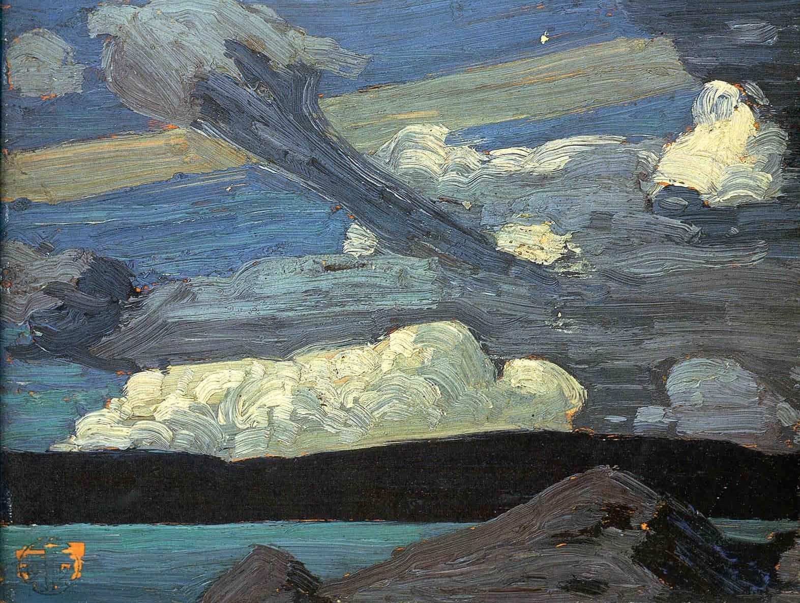
Sketch for "The West Wind" Spring 1916
Oil on composite wood-pulp board 8 7/16 x 10 9/16 in
Tom's Standard Paint Box Size
Now in the Art Gallery of Ontario. 

Tom's patron Dr. James MacCallum says he knew the definitive story about when and where the "West Wind" was created. He was there with Tom, Lawren Harris, and Lawren’s cousin Chester on Lake Cauchon when he painted the sketch. “It was blowing very hard and Lawren Harris was painting further up the shore. The wind blew down the tree of the picture, and Harris first thought that Thomson was killed but he soon sprang up, waved his hand to him, and went on painting.” Dr. MacCallum's note to Miss A. L. Beatty, secretary to the curator of the Art Gallery of Ontario, dated May 14, 1937. 

Lawren Harris also described the cold frontal passage in a 1948 lecture although he did not refer to the "West Wind" by name.

"...one afternoon in early spring on the shore of one of the Cauchon Lakes in Algonquin Park ... a dramatic thunderstorm came up. There was a wild rush of wind across the lake and all nature was tossed into turmoil. Tom and I were in an abandoned shack. When the storm broke Tom looked out, grabbed his sketch box, ran out into the gale, squatted behind a big stump, and commenced to paint in a fury." 

How much proof does one need to conclude that Tom Thomson was a weatherman? Violent spring thunderstorms are typically frontal and often supercellular in nature and Tom painted what followed. 

Winnifred Trainer, Tom's close friend was in correspondence with William T. Little who was writing about Thomson's art and life in the 1950s and 1960s. Judge Little published "The Tom Thomson Mystery", a summary of his research regarding Thomson’s death in 1970. Winnie assured him that Tom had personally told her that the sketch was completed at Cedar Lake in the north of the Park.

Ranger Mark Robinson also tells the story that the original sketch had been completed at Achray on Grand Lake and claimed that Thomson had tried to give it to him. Mark apparently refused and advised  Tom to put it on a much larger canvas during the following winter.  

Tom did indeed start a studio version of the sketch in that winter of 1916-1917. That iconic painting was still on his easel in the Toronto Studio Shack when his friends went to clean it out after Tom died in Jul 1917. Tom had told his fiancée Winnie Trainor that he was "much grieved" by the studio painting and unsure what to do with it to finish it besides destroying it altogether. The West Wind was never completed and Tom was not happy with that work. 

I do not wish to add to the speculation about where and when the sketch was completed. I desire to simply explain the science within this plein-air sketch of which Tom was obviously and rightfully very proud. Tom even took the time to sign the plein-air work which is something that he rarely did.  For a complete and scholarly investigation of the "West Wind" mystery, please visit the work of  Diana at Bob McElroy at "The West Wind".

I have been nose to nose with the "West Wind" sketch and large studio painting many times. Sometimes the best brushwork is the rough and unfinished stroke of uncertainty. Sometimes artists worry and think too much - just my opinion of course.

The Weather Network Interview circa 2004
Tom Thomson, The West Wind Exhibition

Tom’s motivation to “record” this particular observation – the tree, colours of the hills, and the cloud structure. The wind is everywhere in this sketch (included again below) – the water waves, the white caps, the streets of turbulent stratocumulus, the shape of individual cloud elements, the flagged Jack pines ... the wind is in everything. 

It is unclear who titled this sketch but my guess would be Dr. James MacCallum, Tom's patron who had acquired the sketch by 1921. If my intuition is correct, the good Doctor nailed the sketch with the perfect and most appropriate name. 

Another brighter version of the "West Wind" Sketch
Tom Thomson's weather observation tells the story of a cold frontal passage marked by thunderstorms that had cleared and were then to their east. Strong and blustery westerly winds typically follow a cold front and nature responds characteristically.  
Cross-section of a typical Cold front Looking North
as contrasted with Tom's southerly view.
      • The air behind a cold front is colder and drier than the air ahead of it.
      • Surface friction slows the advancing cold air causing a steep slope to the front.
      • The steep slope pushes the air ahead of it rapidly upwards producing vertically developed cumulus clouds.
      • Cold fronts can bring the most violent weather including linear squall lines. 
Cloud Streets of turbulent stratocumulus aligned with the wind
are exceptionally common in the cold flow behind a cold front.

Streets of Backlit Turbulent Stratocumulus looking southerly
on a day similar to when the West Wind was painted.
The streets of turbulent stratocumulus clouds align with those winds in the unstable, planetary boundary layer (PBL) in which the earth and atmosphere freely exchange heat, moisture, and momentum. The cloud streets are spaced apart by a distance roughly equal to three times the depth of the PBL. Helical vortices align with the wind in a process very similar if not identical to oceanic Langmuir Streaks. The stratocumulus clouds are found where the helical circulations come together in an updraft. Relatively clear skies separate the cloud streets where the helical circulations interact as downdrafts. The same meteorological processes explain snowsquall bands in the winter. 
The Spacing of Cloud Streets is about Three Times the
Height of the Inversion at the top of the
Planetary Boundary Layer (PBL) 

Oceanic Langmuir Streaks are comparable to the Cloud Streaks 
that are found in the Atmospheric "Ocean" of air. 
 
Stratocumulus Streets as viewed by satellite over the
Great Lakes behind a cold front (left) with a simultaneous  
image of those same clouds (right) over the
Oak Ridge Moraine near Schomberg

Pictures can be worth many words. Tom Thomson was painting the reality of weather behind a cold front. Hopefully, the preceding science told in many words and pictures proves that. 

The turbulent clouds are clearly darker in the middle and brighter on their edges. Even though the sun is not within the panel, Tom was clearly looking southward and the clouds were backlit. Note as well that the distant shore was in shadow and relatively devoid of colour. It is unusual for plein-air artists to paint looking into the light but Tom didn't have any other option given the orientation of the lake shore.  

Another View of the iconic West Wind Sketch

The lake was full of white caps. The Beaufort scale describing these conditions as Tom painted was at least Number 7 - Near Gales (28–33 knots 32–38 mph 50–61 km/h): "Sea heaps up and white foam from breaking waves begins to be blown in streaks along the direction of the wind. Whole trees are in motion. Inconvenience felt in walking against the wind."  This was consistent with the description of the wind given by Lawren Harris as "gale". 

The gravity waves of the lake surface are aligned perpendicular to those westerly winds. 


PowerPoint slide from "Tom Thomson Was A Weatherman"

Those pines had experienced such winds many times before. Rather than break, the trees bend with the prevailing winds. This process is referred to as "flagging" where branches and foliage grow downwind with the prevailing wind directions. Branches attempting to grow upwind are stunted in comparison. Tom's pine trees were heavily "flagged". The prevailing wind direction in Algonquin and Georgian Bay was and is southwest to westerly. I know of millions of trees that would agree. 

The vitality of the plein-air sketch is often unmatched by the more careful and studied studio painting. Tom certainly felt that and apparently, it "grieved" him. The studio version of the "West Wind" (below) was left undone by his death.

Tom Thomson, The West Wind, winter, 1916–1917,
oil on canvas, 120.7 x 137.9 cm,
 Gift of the Canadian Club of Toronto, 1926
 Art Gallery of Ontario, As restored in 2017

Tom Thomson's sketch for the "West Wind" is a fine example of a gifted artist keeping his oils clean under challenging circumstances. One way a plein-air artist attempts to keep their colours pristine is to avoid mixing them in the first place. Generous amounts of the correct colour are loaded from the palette on a brush and swirled into the correct place within the composition. Load it, drop it and leave it alone. This also requires respecting the boundaries between different colours which allows some of the panel to peek through. The colour of the aged panel or the tinted ground can create a complementary sparkle between the contrasting colours in the sketch. The energy of the oils and the brushwork can make the scene remain vibrant and alive. Tom Thomson achieved that miracle giving life to the oils with a vision direct from nature. 

Tom Thomson Sketch box Palette


Tom left his sketch box palette in a bit of a mess. One does not keep your colours very clean on a disorganized palette. He just didn't have the chance to scrape it clean and start fresh. Tom Thomson had something to say with his brush and we are fortunate to be able to watch and listen.

Warmest regards and keep your paddle in the water,

Phil Chadwick

PS: "Tom Thomson's Ragged Pine 1916" may have been the plein air painting that Tom did during the thunderstorm described by Lawren Harris and Dr. MacCallum in the stories included above. 

PSS: For the Blog Version of my Tom Thomson catalogue raisonné, Google Search Naturally Curious "Tom Thomson Was A Weatherman - Summary As of Now" or follow this link “http://philtheforecaster.blogspot.com/2022/10/tom-thomson-was-weatherman-summary-as.html