The following post will be longer than normal - much longer. Considerable research has been completed to compile the facts with the goal that this will be a worthwhile read.
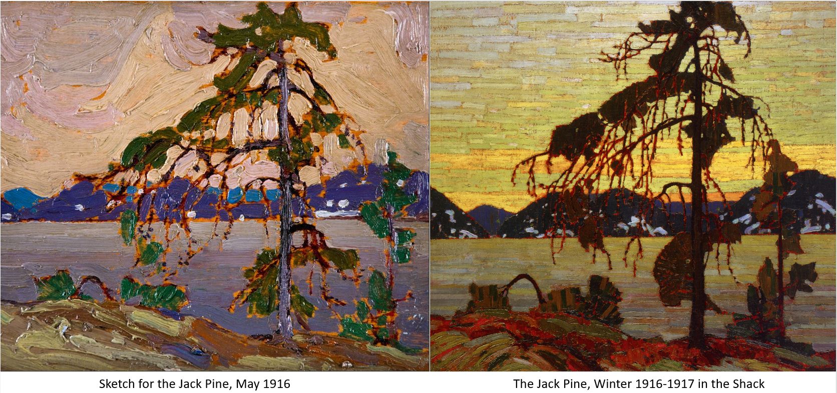
The "Sketch for the Jack Pine, 1916" and the studio painting "The Jack Pine" completed in the Shack the following winter are considered the finest of Thomson's works. A thorough Creative Scene Investigation of all facets of this painting is warranted. Multiple threads of science, art and history weave together to complete the fabric of understanding. Anything less might be considered disrespectful and I would not want that.
Imagine a solitary tree exposed on the rocky shore of a northern lake facing the elements alone. Simply staying alive was a victory. Thomson captured that iconic message in oils. "The Jack Pine" has become the metaphoric touchstone of the Canadian experience. Generations have come to embrace the sketch and the larger studio painting that evolved from the plein air session. Both rank among his very best.
 |
Sketch for "The Jack Pine" Spring 1916
Oil on wood 8 1/4 x 10 1/2 in. (21 x 26.7 cm)
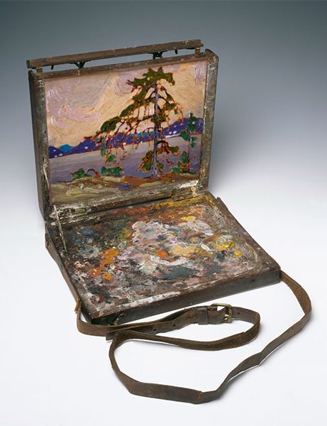
Tom's Paint Box Size |
Thomson had spent a couple of weeks in late April 1916 fishing and painting with Dr. James MacCallum, Lawren Harris and Lawren's cousin Chester. The "Jack Pine" sketch was probably painted in May after Harris had left to report to duty at Camp Borden.
Thomson was supposed to report for Fire Ranger duty at Achray on Grand Lake around May 1st. Old-timers from that area recalled that Thomson initially stayed in the Old Rangers Cabin on the point just west of Achray. That cabin west of the present-day pier is now gone.

Thomson probably found time to paint in May 1916 before the fire season got busy. As Tom noted in his October 4, 1916 Letter to his patron Dr. MacCallum:
"Have done very little sketching this summer as I find that the two jobs don’t fit in. It would be great for two artists or whatever you call us but the natives can’t see what we paint for. A photo would be great but the painted things are awuful [sic]."
Tom Thomson was barely surviving as an artist. The generous encouragement of his artist friends and the financial support of Lawren Harris and Dr. James MacCallum kept him going. Even so, he spent the summer and early autumn of 1916 working as a Fire Ranger. Rare and brief stolen opportunities were all he had to indulge in his passion - recording the bare and broken branches of nature that were also just trying to survive. Large sections of the Algonquin forest had recently been clear-cut.
 The solitary Jack Pine symbolizes Thomson's experience during the final two years of his life. Tom pursued his artistic journey alone while his friends were consumed in the war effort. This particular, reclusive Jack Pine was spared by the loggers because it was worthless. The "ugly snags" would not even produce a 2x4 stick. A December 1912 Arnprior Chronicle suggested the lowly Jack Pine might be used for pulp and paper. However, the tree could provide a habitat for nature. The serotinous conifer relies almost entirely on heat and fire for seed dispersal. Like a torched Jack Pine, Thomson's art was sown after his tragic death to inspire the next generation of artists.
 Ed Godin, the Algonquin Park Ranger who worked with Thomson that summer had recently built a new cabin to the east of the Achray pier. That cabin still stands and is referred to as the "Out-Side-In". Godin reported that Tom moved into the new cabin around Thursday, June 1st. Godin needed a sign which Thomson painted. So began the summer of 1916 with Thomson working as a Fire Ranger squeezing as much painting into the quiet times as he could muster.
Professor Theodore.W. Dwight, of the Faculty of Forestry, University of Toronto was one of the first enthusiasts to attempt to track down the painting places of Tom Thomson.
Professor Dwight spent eleven years at the Forestry School’s fall camp in Achray starting in 1924. Using his photographs of the area, he tried to establish that the sketch for the “West Wind” was painted from the Old Ranger's Cabin but that is another story.
In January 1977 Ronald Pittaway interviewed Professor Dwight (1889 - September 1977) regarding his painting studies (Algonquin Provincial Park Archives & Collections, L-2-86b, Theodore W. Dwight, page 16). Professor Dwight was 88 years old at the time but still recalled many details from Achray 42 years previously. Pittaway also spoke with Thomson's friend Daphne Crombie in January 1977 (see Tom Thomson's "Path Behind Mowat Lodge"):
"Most of the time I was going to Achray, the park ranger there was a chap named Godin, G-O-D-I-N, Ned Godin and I told him this story when I went back the next year, about this painting [Jack Pine or The West Wind]. Oh well, he said, that it probably is here because he said Tom Thomson worked with me when he was on the staff here. They gave him an appointment and I think they told Ned Godin if Tom wanted to go off and paint why they’ll let him. I imagine, he didn't say so. I didn’t raise the question, but he did alot (sic) of painting there while he would be paid by the government you see... Ned retired about 1934..." [Professor Dwight referred to Edward Godin as "Ned" during the interview and those notes will remain as such.]
Thomson felt he didn’t have enough time to paint but apparently, Ed Godin, his boss let him go and paint whenever… the government was paying. In my opinion, that was the best money ever spent by our parliamentarians!
The above photo from the Algonquin Park Archives includes left to right: R. Boultbee, T. Kelly, Professor Dwight, Taffy Bastock, Frijof Plahte, Pete Addison, Jack Matthew, Jack Robinson and Sid Frances standing outside the Ontario Forestry Branch 1927. Pete Addison was the husband of Ottelyn Addison (1908-1997) Mark Robinson's daughter. Jack Robinson was Mark Robinson's son.
Recall that Ranger Mark Robinson (1867 - passed in 1955 aged 88 years) was a personal friend of Tom Thomson. Mark and his family play important roles in the Tom Thomson story. Recall that young Jack even assisted his father Mark in the search for Thomson when Tom went missing in July 1917. Mark's daughter Ottelyn wrote "Tom Thomson: The Algonquin Years" - an important account to make readers more familiar with the circumstances of Thomson's life during his Algonquin years and to help them visualize his surroundings.
In Professor Dwight's interview, he mentions ranger Bob Balfour. Balfour also worked with Mark Robinson in the southern part of the Park.
Professor Dwight applied the same approach to the “
Jack Pine” and decided it was painted from the point stretching out into the lake just to the west of the Out-Side-In - immediately east of the modern dock.
Professor Dwight took photographs of the skyline across the lake as it appeared circa 1935 and compared it with the hills in the “Jack Pine” background. Even allowing for changes brought about because of the tree growth in the intervening years, the similarity between the two was intriguing but not quite right. The portion was omitted because it was not visible from the location where Thomson made his plein air sketch.

Professor Dwight's enthusiasm for Thomson's art is inspiring. His photography is essential to solving some mysteries even though his painting site was 800 metres too far northwest. I attempted to match up the numbered hills to match Professor Dwight's analysis. I also assigned some "Hills" with letters for further explanation. Note that the "Sketch for the Jack Pine" again shows Thomson's tendency to exaggerate the vertical extent of distant landforms. This is a typical practice for plein air artists to better fill the panel. Also, note that Professor Dwight's photos show a lot of exposed rock on those cliffs even twenty years after Thomson painted.
The McElroys of Point Alexander among others followed in the research of Professor Dwight. The McElroys provide a wealth of information regarding the travels and art of Thomson, especially in the areas around Achray. See Grand Lake -Tom Thomson Sketching Locations for fascinating details they have discovered. I rely extensively on their research and first-hand knowledge of the area!
The McElroys write:
"The Jack Pine Site is about a 10 minute walk along the railway tracks, east of the Out-Side-In. A walking trail has now been established leading to an interpretive plaque at the site of the sketch."


The above comparisons based on photos taken by the McElroys prove that the accepted vantage of the sketch (middle image) provides a much better match than that from in front of the Out-Side-In as suggested by Professor Dwight (bottom image). It is quite surprising how the features change significantly with a shift of only 800 metres between the two vantages. The McElroys even matched specific rocks and trees in addition to the distinctive round-topped Hill A and peaked Hill B.
Thomson's sketch for the "Jack Pine" displays all of the characteristic terrain features that the McElroys photographed 99 years later.
Important changes in the terrain around Grand Lake in the last century can be identified from the archival photos. Although the vantage of the 2015 McElroy photo from the beach in front of the Out-Side-In might be slightly different from the 1935 image taken by Professor Dwight, some interesting changes can be witnessed. 
The forest had certainly recovered a bit between Thomson's 1916 painting and Dwight's 1935 photo. The trees of the Algonquin forest matured even more in the following eighty years when the McElroys were conducting their research. The exposed rocks of the steep slopes were mainly hidden by 2015. The shapes of Hills A and B were still readily identifiable.
The following 1975 image from the Algonquin Park Archives is thought to be the actual tree that Thomson sketched.
The terrain outline (dashed purple line) was traced from the dark purple of Thomson's sketch with the height reduced by 35%. The water level of the far shore of Grand Lake and the location of the Jack Pine in Tom's painting are also included. The assembly of lines was then matched as best as possible. It might have been a better correlation if the 1975 image had been taken a few paces to the left. This highlights just how challenging the identification of a painting place can be.
The McElroys identify this Jack Pine as a "wolf tree" and observe:
"a 'wolf tree' - one that has grown up in the open and thus has had room to spread out sideways rather than have to stay skinny and grow tall to get enough light in competition with its neighbours. One thing about this tree is that many of the branches are depicted as emerging from the trunk horizontally or angling downward. In real life, jack pine branches angle upwards from the trunk then turn over and begin the characteristic droop. Perhaps Tom was not that concerned with the actual physical details but more with expressing a certain feeling embodied by the tree (in which he succeeded)."
My Thomson friend continues:
"It is interesting that the photo from the Park archives purporting to be of the tree in later years (and quite dead) shows a tree with a lot more branches, all of which angle upward from the trunk. I am dubious about identifying it as 'the tree', since it bears no resemblance to the sketch, and also I'm not sure exactly where it was."
More than a century later, any examination into the specifics of the tree that Tom painted requires a lot of handwaving and conjecture. However, years of investigation have correctly located Thomson's plein air session for the sketch. That site is now much easier to find along a groomed trail. A comfortable bench and a display board with detailed information will reward any hike to the site.
 |
The Jack Pine location as photographed in 2003 looks toward the southwest and Thomson's view.
The Jack Pine was long gone. |
The McElroys photographed and wrote the following in 2015 - used with their generous permission.
Apparently, that fallen, dead jack pine was used for firewood. Of course, no one will ever know if it was THE Jack Pine...
Jack Pines (Pinus banksiana) are found in the northern portions of Algonquin Park and range from 30 to 72 feet in height. Poor growing conditions limit some Jack Pines to the size of just a shrub. Jack Pines do not usually grow perfectly straight. They tend to be irregular in shape similar to pitch pine (Pinus rigida). Jack Pines often form pure stands on inhospitable sandy or rocky soil.
Jack Pines are adapted to survive fires. The cones can remain closed for many years waiting for the next blaze to torch the mature trees. The cones sealed shut with resin open and reseed the burnt ground. The resinous cones typically require 50°C to open although cones on lower branches have been observed to spread seed with temperatures of just 27 °C. This is the result of added heat being radiated from the ground. Climate change will see those temperatures routinely experienced in the coming decades.
And now after much delay, it is time for the weather. I reached out to my colleague Johnny Met for a second opinion.
"When I graduated from weather observing school 60 years ago, I lacked confidence in looking at the sky and making a quick, cold decision. Having a synoptic knowledge of what was happening would help, as would a trend of thickening clouds or clearing behind a cold front.... I can imagine the artist painted the sky first, added the hills, then the lake, the tree, and the foreground. The artist painted the cloud and its chaotic motion. He has stated the cloud is shaped in a sine wave with troughs, ridges, and troughs. The colours are acute: white, dark brown, lighter brown, beige, and grey. All of the technicolour could be associated with a sunset. Imaging a synoptic picture related to the painting could be a warm front invading the sky from the west; the sine wave action puzzled me. I can only think of turbulence caused by midlevel instability."
I am in complete agreement with Johnny's observations. Situational awareness is fundamental to observing and understanding the weather. An observer must place the clouds into the context of the larger weather situation to fully understand what the clouds reveal. Making a "cold decision" lacks the facts of the broader nature of the meteorological conditions. In many ways, Creative Scene Investigation is the same placing the art of Tom Thomson within the larger context of the natural environment.

The warm front surface aloft can be thought of as a blanket stretched over the cooler air of the cold conveyor belt. Strong winds can shake the blanket inducing gravity waves in the stable layer. The warm air above the frontal surface was certainly quite unstable with the up and down drafts of the embedded convection adding to the high amplitude shape of Johnny's "sine wave" (the pale blue arrow in the graphic). Unstable altocumulus castellanus is common above the warm frontal surface within the cyclonic companion. The convective tops of these clouds were above the edge of the small panel.
Thomson's expressive brush strokes followed the high-amplitude gravity waves displayed in the clouds from left to right. The stronger winds required to generate Johnny’s trigonometric cloud description would most likely be found in the cyclonic companion of the warm conveyor belt - near the vortex of the developing low-pressure area. The analogy with water waves is apt with larger waves associated with stronger winds. Instability in the warm air mass can also magnify the amplitude of the gravity waves. It is a plausible question to ask whether Thomson was more inspired by the weather or the Jack Pine...
These deductions allow us to place Thomson at the yellow star within the conveyor belt conceptual model. Thomson was south of the cirrus deformation zone but north of the surface warm front.

Recall that ice crystal clouds are translucent to the sun. Even backlit cirrus clouds are not dark in their central mass! The high-level cirrus deformation zone had already passed north of Tom's painting location, but the sun could still illuminate the landscape.
The timing of this sketch had to be later in the afternoon - perhaps early evening. When the sun is lower in the sky, Rayleigh scattering ensures that the colours of the sunlight become void of the shorter blue wavelengths after passing through longer atmospheric paths. Given the viewing angle of the painting, the sun would have to be in the west-to-northwest portion of the sky.
To summarize, Thomson was watching the approach of a warm conveyor belt weather system from the southwest. The cyclonic companion of the system was lined up with his location on the eastern shore of Grand Lake.

I admire Johnny's passion for the painting but I suspect Tom laid in the trees first and stabbed in the oils between the branches afterward. Of course, every opinion is equally valid as literally, no one was there to watch over Tom's shoulder to see which order he did his brush strokes.
 |
| The pale white arrows attempt to match the direction of Tom's brush strokes. |
Johnny Met's weather observation and the cloud colours allow us to accurately place Thomson within the weather pattern. A classic spring storm was approaching from the southwest as is typical for Algonquin. The surface warm front was still to the south. Tom was in the cold conveyor belt flow of the weather system. Easterly winds can be inferred since the lake was calm along the sheltered eastern shore of Grand Lake. The winds in the cold conveyor belt are only calm or easterly when the approaching system is either approaching very slowly or is stronger than average or both.
Further investigation is required but the following is quite possible. The cold frontal passage that Tom painted in "West Wind" could have been on the back side of the same weather system that he witnessed approaching in "Sketch for the Jack Pine." The probability of this coincidence increases with the strength, size and slow-moving nature of the spring storm. The evidence for this can be found in the cold conveyor belt. Like everything Thomson, we will never know for certain.
One final piece of evidence to time this painting is the probable absence of biting insects in May. Tom like most plein air artists did not enjoy bugs swarming his face while he painted. Any exposed skin was a dinner call to the little biters. When an artist gets in "the zone", blood dripping into your eyes or off your nose might be the first indication of extensive bug bites.
Tom mentioned in his last known letter sent to Dr. MacCallum just days before he died that "bug dope was not having any effect". The spring of 1917 was wet with lots of bugs. The weather in 1916 was fairly hot and dry which would tend to discourage the biters. It is still unlikely that Tom painted this sketch after the biting bugs emerged in late May. The really pesky black flies typically start to swarm around the Victoria Day weekend in Algonquin regardless of the weather. If Tom had been painting with the biting bugs, a forensic examination of the oils might reveal some insect body parts. I often mash the biters into my oils while painting...
In addition, the "white spots" on the northwest faces of those hills are often interpreted as snow implying an early spring painting session rather than May. There was precious little soil on that clear-cut terrain. Some of the very limited soil was even washed away without the protective cover of trees and their root system. Some of those stabs of white paint are circled and colour-coded in Tom's painting - the lower right of the following graphic.
Professor Dwight's 1935 photos in the lower left above match those white stabs of paint. Even though the forest had largely recovered in the century since Tom made his observation, the above McElroy image from the correct vantage of "
Sketch for the Jack Pine" matches the white brush strokes very well - including that of Grey Rock within the blue oval. The rock was painted "white" by gull guano. Nature is the one constant in the environment and apparently, the gulls liked to perch and rest on that rock even back in 1916 when Thomson depicted it with a stab of Freemans' or zinc white.
Thankfully Tom painted what he saw. Unfortunately, many art lovers do not share his breadth of experience. Thomson did not write notes about what he painted on his panels. Any comments would have removed much of the speculation that we endure a century after the fact.
The following application of the "rule of thirds" to "Sketch for the Jack Pine" implies that Thomson deliberately bent the rules that did not conform to the inspiration in front of him.
Finally, the following 2017 discussion is courtesy of the Friends of Algonquin Park:
“As part of our recent “Algonquin Park in the 1910s” exhibit, we presented a paint chip that was discovered on a tree stump by archaeologist Dr. C.H.D. Clarke, in 1955. It came from Grand Lake, which is an area that Tom Thomson was known to paint. We have wondered if this could really be a piece of Tom Thomson’s paint that he left behind in 1916. Originally, we wanted to have the paint chip analyzed to get a better sense of its composition and a more accurate date, but unfortunately this process was beyond our budget. So for now, without further analysis this cannot be confirmed."
"With that being said we thought it would be fun to hold a vote with our visitors to see what your thoughts are- the exhibit has now come to a close, and the results are in. 1040 people voted in favor of this being Tom Thomson’s paint, and 362 voted against it. We are glad that so many of you participated in this vote, and hope that it sparked some debate among the different groups that visited.”
I toured and presented at many Ontario Provincial Parks in the summer of 2017. One park accidentally billed me as being Tom Thomson! I first saw the above paint chip when I presented that year in Algonquin Park. I am one of the 1040 (
74%) who thought that "
yes indeed", those oils were scraped from Thomson's palette. Oils do not stay useable for very long in the heat of the summer. Plein air artists, myself included, will often scrape their palette knife or brush on a tree...
- u.l., in graphite, 13 / Top left;
- c.l., in ink, C&V / 19-3-47 / F.W.;
- t.c., in ink, [illegible] The Weir Foundation, RiverBrink, Queenston, Ontario (982.65)
Provenance:
- Mrs. B.P. Watson, Toronto and New York, 1917
- T. Eaton Co., Toronto, 1947
- Samuel E. Weir, London, Ontario, 1947
- The Weir Foundation, RiverBrink, Queenston, Ontario (982.65)
I wonder how Mrs. Watson acquired this painting in 1917. This painting was neither signed by Thomson nor scarred by the Estate Stamp. The painting was acquired before the spring of 1918 when Harris and MacDonald sorted through the pile of panels left in Thomson's Shack. I imagine that there is an interesting story to be found there.
As noted above, the original sketch can be found in the RiverBrink Art Museum. Sam Weir purchased the painting in 1947 and in his own words:
"I have built a foolish house on the Niagara River with the idea of leaving it for a museum, art gallery, library, etc., mainly Canadiana. I expect there will be no inheritance taxes. This is my idea of doing good in my life or at the end of my life."
Sam Weir passed in 1981, leaving his collection and estate to the Weir Foundation, incorporated in 1962. The
RiverBrink Art Museum would be well worth the drive to Niagara on the Lake if just to see "
The Sketch for the Jack Pine".
I do not recall ever seeing "The Sketch for the Jack Pine" in the flesh. One of my Thomson friends who I highly respect, had the following to say:
"I think it's unfortunate that nowhere have I seen a good reproduction of this sketch. For years I thought it was a bit of a dud, until I saw the real thing. It is, in fact, absolutely stunning and somehow luminous, which is quite a feat with opaque, reflective paint. Tom was a genius with paint."
Further, Dr. James MacCallum observed:
“Thomson painted not merely to paint, but because his nature compelled him to paint — because he had a message. The North Country gradually enthralled him, body and soul. He expressed the emotions of the country, its moods and passions, and all the sombreness and glory of colour. Words were not his instruments of expression. Colour was the only medium open to him.”
More than a century after Tom's passing, another Thomson friend, author Geoff Taylor and writer of "Tom Thomson's Last Bonfire" recently remarked:
"Thomson lies in the grey mists between fact and fiction like an elusive shadow only glimpsed from the corner of your eye. Always out of focus. Because so little is known of the man, Tom's life and demise are rife with speculation. Rugged outdoorsman, groundbreaking artist, principled pacifist, wandering lover, you are able to project your own story onto his character."
Interest in Tom Thomson remains at the forefront of Canadian Society in 2024 - see August
Cottage Life Magazine for my friend Roy MacGregor's article. I wonder if troubling political and economic times can prompt people to search for their safe, comfort zone – often found within the nature that parks provide – forest bathing if you like. Thomson’s art portrays those sanctuaries. Who can look at a Thomson painting and not see nature or something even much greater? Tom was authentic and painted what he lived. That resonates with people. For those unable to get to a park, solace might be found in any of the Thomson art books.
The story behind the art can be just as compelling as the brush strokes. Appreciating who, what, where, when and why of a painting allows us to almost stand overlooking Thomson’s shoulder as he painted. Enthusiasts will search for years trying to locate exactly “
where” Tom stood (
or sat) so that they might do the same. The “
Tom Thomson Was A Weatherman” blogs provide information on the other four “
Ws” based purely on science and the uncanny accuracy of Thomson’s observations.
 |
| It is interesting how Thomson moved the distant shore of Grand Lake downward closer to the Horizontal Lower Third. Also, the undulating gravity waves were replaced by layered altocumulus in the studio version of The Jack Pine (right). There are no rules in art. |
Through the decades of PowerPoint presentations and articles, many passionate and extremely knowledgeable people within the Thomson community have become my friends. Their contributions are included to complete the stories behind each of Tom’s panels. The science developed in the last century allows us to better appreciate the motivation for Tom to paint what he did. He recorded some esoteric meteorology. Tom loved the weather! He might have been the first to paint an EF2 tornado en plein air.
Thank you for taking the time to read this special post "Sketch for the Jack Pine"! Appreciating Thomson with fresh eyes and science reveals truths painted in plain sight but possibly never acknowledged.
Warmest regards and keep your paddle in the water,
Phil Chadwick, Tom Thomson Post TT-133
PSS: The "
Sketch for the Jack Pine" in the National Gallery circa 2014-15, but it really doesn't show how lovely it is. The lighting was low supposedly to protect the works, and it was also behind glass and at an awkward angle. It is symbolic that a thing of intimate beauty was displayed to conceal that honest observation of nature… oh my...
PSSS: I even have Jack Pine Tea and Coffee Mugs...