Search This Blog

Wednesday, August 24, 2022

Tom Thomson's "View Over a Lake" 1916


Tom Thomson spent his last full summer working as a fire ranger out of Achray on Grand Lake in Algonquin Park. Tom would produce some plein air master pieces in between doing his day job. 

Grand Lake and the Out-Side-In, Tom Painted the Jack Pine
sketch and others during the last summer of 1916
Tom’s art career lasted barely five years during which time he completed about 400 plein air paintings. These “sketches” breathe a life and vitality that is often lost in the larger works.  Most of these small panels were unsigned and untitled. Tom also did about 50 larger works and these he did autograph and probably had a role in naming. 

View over a Lake, Autumn, 1916, oil on wood
21.5 x 26.7 cm (8.5 x 10.5 inches), Purchased 1918
National Art Gallery of Canada
After Tom died on July 8th, 1917, the effort of archiving and establishing the catalogue raisonné of these sketches became the job of his friend Lawren Harris and Tom’s patron Dr. James MacCullum. They faced huge challenges with inventing distinctive names for panels that Tom Thomson didn’t even take the time to sign. I can almost hear the resigned, sigh of exhaustion when they attempted to uniquely name yet another mix of clouds. A “view over a lake” is a generic stretch for an observation of weather that clearly says a very lot more. 

The Out-Side-In was Edward Godin's cabin at Achray.
Tom Thomson even painted the "Out-Side-In" sign for
his friend to hang on the porch.  Godin shared his
cabin with Tom during that last summer of 1916. 
Bob and Diana McElroy have already done considerable research into this painting. They ascertained that “this scene was painted from right in front of the Out-Side-In. The pink areas on the far hill are patches of bare granite. These areas are now largely obscured by the current tree cover but are quite findable if you choose to climb the hill.”

When I was on Meteorologist Orientation Course 33 back in 1976, we were never allowed to give the answer of “large scale dynamic” in response to any weather question. If there was cloud or weather, it was always assumed that there was ascent in the atmosphere and to say that was not worth marks in any exam. 

The same applies to the name “View over a Lake” that was selected by Harris and/or MacCallum for this plein air painting. Describing that skyscape as simply another vista over a body of water is similar to describing clouds as large scale dynamic lift. Tom’s motivation was certainly the clouds and the sunrise colours on the far shore of Grand Lake but there is so much more to understand. I will try to use as many graphics as possible to save on words but still convey the meteorology of that sunrise. I hope you persevere and read on. 

The solution to understanding this painting is to establish where Tom was looking within the Conveyor Belt Conceptual Model (see Dancing with the Weather). This is the same approach I always employ with clouds in the free atmosphere. I described that method in Tom Thomson's "Sunset" 1915

The first thing I do in this regard is to select my Coriolis Hand (your right hand in the Northern Hemisphere) and try to line up my fingers with the likely direction of the wind. I often try the opposing wind direction to figure out which interpretation fits most of the puzzle pieces into the meteorological picture. It is best to always keep an open mind. You can learn more that way. I applied this technique to “View over a Lake” and came up with the following diagnosis. 
Imagine the westerly jet stream blowing out of the panel… the extreme right side of the painting is the cyclonic companion where there are no holes in the thicker cloud cover. The left side must be the anticyclonic companion of the warm conveyor belt and notice that the clouds are more scattered. There is a convenient line in Tom’s sky where I placed the axis of the westerly jet stream pointing toward the col in the deformation zone. I included Tom’s position as a blue circle in the graphic. 

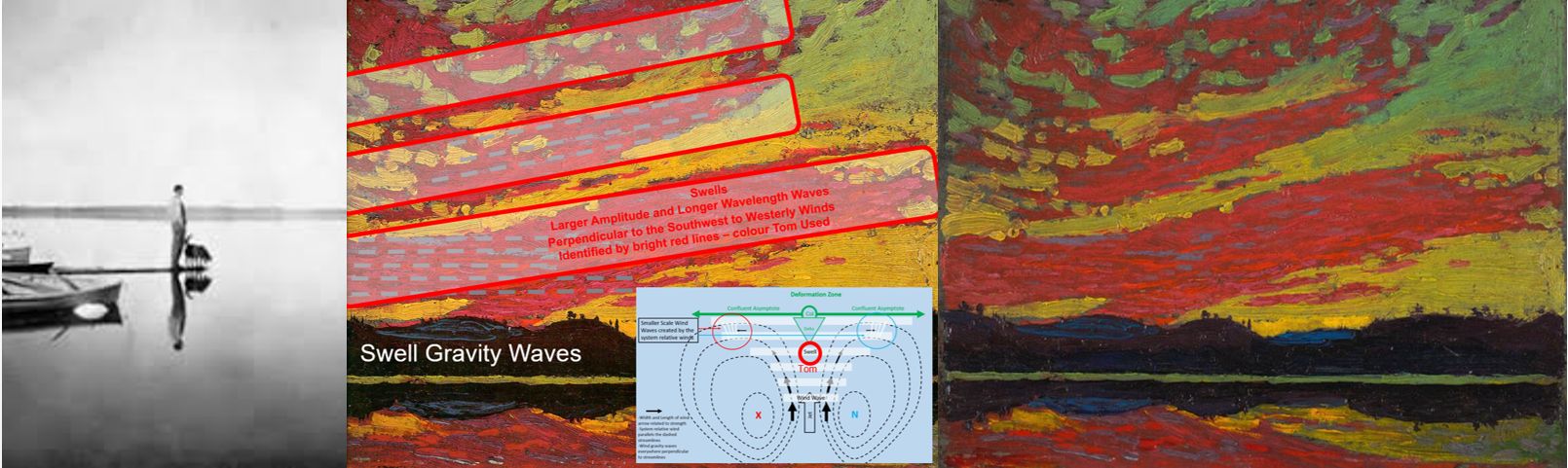
As confirmation, I aligned my Coriolis fingers along the elongated wisps of cirrus (the blue arrows) and found my right thumb pointing downward. This is also consistent with the anticyclonic companion of the warm conveyor belt. 

This east to west cross-section through the approaching
warm conveyor belt has the cirrus deformation zone
already to the east of Tom's position with him sketching
the altostratus deformation zone as it approaches.  
I then noticed a darker and greyer band of cloud lower on the horizon – about a third of the way up from the bottom of the panel. Artists are well aware of the rule of thirds for compositional effect. This thick cloud would be the leading edge of the altostratus cloud comprising the warm conveyor belt. I call that line the altostratus deformation zone. 

Notice also that Tom included some gravity waves in the leading edge. Those wind waves are identified with the wavy light blue line. The amplitude of the waves increase to the left away from the col of the deformation zone. These wave clouds conform nicely to the deformation zone conceptual model. The wave pattern in these clouds would be drifting to the left further away from the col while Tom painted. 
Satellite view looking down on the warm conveyor belt. Tom
sketch the wind waves rippling southward from the col.
Notice also that Tom included some gravity waves in the leading edge. Those wind waves are identified with the wavy light blue line. The amplitude of the waves increase to the left away from the col of the deformation zone. These wave clouds conform nicely to the deformation zone conceptual model. The wave pattern in these clouds would be drifting to the left further away from the col while Tom painted. 

From these observations we can be certain of Tom’s vantage within the Conveyor Belt Conceptual Model of the approaching storm but what about the light?

The clouds are front lit and uniformly bright throughout their flanks exposed to the sun and Tom’s gaze. The sun would be shining on Tom’s back and it would feel delicious. The quartz rocks were bright, colourful and clearly not in shadow. The direct light from the sun would pass through a long expanse of atmosphere. Rayleigh scattering would deflect the shorter blue wavelengths out of that direct beam. The sunrise light would be rich in the longer wavelength red hues and would set those rocks on fire for Tom to paint. Tom loved those early morning and evening colours of sunlight. 

Those colours were not the autumn foliage of deciduous trees. There are no autumn colours in this landscape so to call this fall would be a stretch and is certainly in error. 

Tom’s window of opportunity to record this sunrise light would be brief. The cirrostratus deformation zone had already passed overhead and east of Achray. The rising sun would soon be blocked by that layer of clouds. In this situation, the period of “golden light” at sunrise might only last a few minutes. The accompanying graphic explains those concepts. 
The cirrostratus deformation zone has already passed east of the Outside In. The sun had just risen in the east but not far enough that the direct beam was blocked by the cirrostratus cloud. There is at most only about 30 minutes within this sunrise window before the pink light of dawn would be lost. Tom had to paint fast. The above graphic displays the isentropic surfaces of the warm conveyor belt - but it is not distorted nearly enough to reveal the actual, thin nature of the atmosphere which is comparable in scale to the skin of an apple. The wedge of clear skies that allow the sunrise light to illuminate the far shore of Grand Lake is really thin indeed. 

But wait, there is more… The waves on Grand Lake also provide a clue as to how fast the weather system was approaching. There was considerable wave action for a sunrise. This means that although the skies were clear for most of the night before the cirrostratus arrived, a radiational inversion that would block the winds from the free atmosphere from reaching the ground, did not develop. The storm was approaching quickly. I explain these concepts in a blog about the importance of the cold conveyor belt

The bulk of the weather was headed north of the Out-Side-In with the cyclonic companion of the warm conveyor belt. The fast moving weather would not last long when it did arrive in just a few hours. The altostratus was on the horizon and any nimbostratus with rain could not be far behind. Tom would then just have to wait for the cold front and possible summer convection.

So taking a closer look at a “View Over A Lake” tells the full story (notice that I removed the word "Autumn"). Tom got up with the sun and took the time before heading out to be a forest fighter to knock off a quick thirty minute weather observation of the sunrise and approaching summer warm frontal storm. Earning a salary can get in the way of making art. The warm frontal rain would arrive by mid morning but be spotty in nature and not last very long. Then it would get warmer and muggy with gusty southwest winds. There is no way to predict how far to the west the cold front was. That depends on the size of the warm sector of the storm and that is highly variable depending on how far away the low and centre of the storm was in relation to Achray. 

The isobaric pressure pattern and the conveyor belt conceptual model
views of the same weather system. How long it takes for the system
to pass you by depends on the cross-section and the storm motion.

Tom Painted what he saw. The clues to the nature of the moment were clearly hidden in his brushwork. The challenge has been to not read too deeply into those bold strokes .. just the facts. Some of this science I discovered from observing the atmospheric ocean during my 36 years with Environment Canada. Some is based on the work of others like Bob and Diana McElroy. I am indebted. We all stand on the shoulders of others in one way or another so that we can see better and perhaps further. The goal is to learn and understand and appreciate nature. 

A “View Over A Lake” is a not so simple. That scarlet sunrise shimmers with science. Tom’s art does speak for itself but I am here to help those who may not be meteorologists. I feel that it is important to understand a bit deeper why Tom painted what he did – to better complete the catalogue raisonné. (A comprehensive, annotated listing of all the known artworks by an artist - described in such a way that they may be reliably identified by third parties.)

Warmest regards and keep your paddle in the water,

Phil the Forecaster Chadwick

PS: Give yourself another Gold Star if you read all of this... thank you!

PSS: For the Blog Version of my Tom Thomson catalogue raisonné, Google Search Naturally Curious "Tom Thomson Was A Weatherman - Summary As of Now" or follow this link “http://philtheforecaster.blogspot.com/2022/10/tom-thomson-was-weatherman-summary-as.html

Saturday, August 13, 2022

Tom Thomson's "Sunset" 1915

Which comes first - the scene or the science?

My approach to studying a Tom Thomson skyscape is essentially a logical flow chart. All branches of science and nature can come into play eventually but I always start with the meteorology. The horizon is very low on the small panel making "Sunset" another skyscape and an observation of the weather for Tom Thomson. There are actual many "Sunset" works in Tom's portfolio. Lawren Harris and Dr. James  MacCallum were apparently running out of unique names for the growing number of Tom's skyscapes. 

The first question is what is the predominate cloud type? If the cloud is in the lowest levels of the atmosphere, one must apply the science of the planetary boundary layer (PBL). If the clouds are higher in the free atmosphere, then the Conveyor Belt Conceptual Model (CBCM) is the one you typically require. Conceptual models tend to point north by convention. They apply equally well when directed to the northeast or east should that be the direction of the system motion. 

"Sunset 1915" is a painting of clouds in the middle layers of the atmosphere. The diagnosis of Tom’s painting reduces to locating what part of the conveyor belt conceptual model (CBCM) was crossing his location while he painted. For your convenience, I have included important links that more thoroughly describe the features being discussed but if you have already followed these Blogs, you might be able to continue without that background information. Do not feel intimidated... it has taken me a lifetime to attempt to understand the weather that surrounds us everyday. Any challenges are the result of me not explaining it clearly enough... please forge onward. 

Tom Thomson, Sunset, 1915
Oil on composite wood-pulp board,
21.6 x 26.7 cm (8.5x10.5 inches)
  National Gallery of Canada, Ottawa

There are several give-away facts in Tom Thomson's "Sunset" from 1915. The backlit, sunset clouds clearly reveal the westerly direction that Tom was looking. If we had the date, we could narrow his view down to the nearest degree and the time to the minute. 

This is a warm conveyor belt and part of the larger conveyor belt conceptual model (CBCM) for mid latitude, large-scale synoptic storms. With the identification of this pattern, a wealth of information immediately becomes available to explain the current and future weather. The full explanation of the CBCM takes  a dozen blogs and those can be found starting with "Dancing with the Weather" as well as in several other locations. But there are still some very interesting things that can be discovered without diving too deep into the data. 

The significant expanse of altocumulus cloud reveals large scale dynamic lift in the atmosphere which is characteristic of the warm conveyor belt portion of the CBCM. This ascent occurs when air parcels ride the constant-energy (isentropic) surfaces for free. You might recall that these isentropic surfaces slope upward toward the north. You can actually see that slope in Tom’s painting!

The sharp edges to the multiple bands of clouds are the next important clue. These long and well-defined edges can only be deformation zones or the edges of gravity wave clouds. I may have been known as Mr. Deformation  because I found the answer to almost every question in a deformation zone. But not in this case! These are gravity waves and Tom included the clues in his painting. 

Tom's location within the Warm Conveyor Belt is the red circle
where both the wind gravity waves and swells are aligned in 
the same direction perpendicular to the wind within the
atmospheric frame of reference. There are some cloud clues
placing Tom in the left side of that circle as the wind waves 
are angled slightly across the swells - but I do not wish to
read too much into every brush stroke...
There are in fact two different types of gravity waves in Tom’s brush strokes – wind waves and swells. I blogged about these in "Wind Waves and Swells and Lines in the Sky" as well as a few other places. I am certain that Tom was within the red circle of the warm conveyor belt when he observed "Sunset". The accompanying slide from my "Tom Thomson Was A Weatherman" PowerPoint presentation will save some written words and includes that red circle for his location. 

The following graphic illustrates how smaller amplitude and shorter wavelength wind waves can be superimposed on the much larger amplitude and longer wavelength swells. Significant swells can be observed generated from strong winds long distances away - like the wake of a large boat being observed far away on the opposite shore of a lake. 

Both the wind waves and swells are aligned. This reveals Tom locations to be well south of the col in the deformation zone pattern where the atmospheric frame winds flow perpendicular to the swells generated by strong winds at the centre of the weather system. 

I added the lifted condensation level as the dashed red line in
this graphic to illustrate how it can dramatically change our
view of the cloudy wave crests and clear troughs of the
gravity waves as painted in "Sunset 1915"

Tom included the smaller amplitude wind waves - dashed grey lines.
Tom's grey lines correspond to the wind wave crests and thicker
amounts of cloud as they line up and extend beyond the edge
of the swell crests

In the accompanying graphic, I highlighted the larger amplitude swell crests within the red boxes. Note that the lifted condensation level must be below the equilibrium level in the wave pattern (above Option 4 and included as the dashed red line in the Wind Wave Plus Swell Graphic above). The relatively cloud free area in the swell trough is more narrow than the cloudy areas of the swell crest. If both crest and trough bands were the same width, the lifted condensation level would be found at the equilibrium level in the wave pattern. 

Tom was observing the atmospheric ocean. Those bands of clouds within the warm conveyor belt are large swells with the smaller wind waves superimposed. The clouds have sharp edges and occur at the same level in the atmosphere which is a characteristic difference from what one would expect and observe with deformation zones .. but that is another story. 

One final note.. the cloud on the right side of the panel and overhead are higher along the isentropic surfaces than the more distant clouds to the southwest. The orientation of the gravity wind waves actually turn clockwise with height. This veering of the wind direction with height reveals that warm air is being advected with those winds - something I blogged about in "Shifting Winds? Why?". This is consistent with the warm conveyor belt as well as it pumps warm and moist air northward, riding for free up the isentropic surfaces. 

From the preceding discussion, we can be very confident that Tom was within the red circled area of the CBCM. The deformation zone leading the high and thin cirrostratus was already far to the northeast. The wind waves were blowing in almost the same direction as the swell. The weather and possibly nimbostratus cloud were getting closer. 

Calm Waters, Sun Glint and the White Line
Now note the calm surface of the lake. The distant shore and the sky are mirrored perfectly in the calm waters.  The planetary boundary layer (PBL) has already decoupled from the increasing southwest to west flow aloft.  This could be the result of the quick development of the radiational inversion with sunset. An inversion occurs when the rapid cooling of the earth’s surface and adjacent air leaves the top of the planetary boundary layer relatively warm. Warm air overlying colder air is a stable configuration (inverted from the typical situation in the atmosphere) that prevents the wind in the free atmosphere from penetrating to the surface. The strong winds that created the gravity waves aloft could not get past the stable warm inversion and reach to the surface. 

The tranquil winds could also be the calm before the storm. I wrote about this process in a blog about the importance of the cold conveyor belt. Essentially the approach speed of the system might be nearly equal and opposite to the storm inflow winds along the cold conveyor belt. The two opposing wind components can balance out leaving the negligible surface winds as the calm before the storm. 

The other interesting feature of the water surface is the yellow line on the distant shore. This is sun glint from the calm water and results from the increasingly large water surface area subtended by the artist’s eye as you look at those reflective, glancing angles. Tom's vantage was very low - perhaps even from his canoe, so Tom painted the maximum amount of reflected line possible. A graphic from my presentation might help to explain this concept of sunset light reflected at glancing angles from distant water surfaces. 

The PowerPoint interaction of this slide is complicated with arrows
and interactions whizzing about. What it shows is that the viewer
sees more surface area at a glancing angle to the water. The larger 
viewing area reflecting more light to your eye explains the 
white or yellow line in this case that Thomson observed and painted.
Reflection greatly exceeds refraction at these glancing angle as well.
Refraction of light dominates reflection when the viewer looks
more directly down into the water.  

Finally, the rich red colours in the clouds and orange shades in the sky were strongly influenced by the May 22nd, 1915 eruption of Lassen Peak in north central California. The Lassen Peak eruption was tiny compared to the major eruption of Mount St. Helens in 1980 but the effects on the sky were still noticed by the artists in Algonquin - and after all, they painted what they saw. 

Sulphur dioxide spewed from volcanoes reacts in the atmosphere
to form sulphate aerosols (aerosols are tiny, suspended particles in the air).
Rayleigh scattering by volcanic ash and aerosols preferentially scatter the
shorter blue wavelengths out of the sun's direct beam. The direct beam passes
through a long path of atmosphere at sunrise and sunset leaving only
longer wavelengths of orange and red to illuminate the scene.

My PowerPoint slide shows Rayleigh scattering of short wavelength light
out of the direct beam from the sun. The sulphate aerosols from
volcanoes do a good job at removing the longer green wavelengths
as well. Mie scattering forward scatters the light that the clouds intercept
… which is red and longer wavelengths only. Tom saw red clouds. 

A "simple" sunset painting probably completed in 30 minutes or less is far from being straightforward. I spent a lot longer than that just trying to explain what Tom observed. Tom certainly worked on this small 8.5 by 10.5 inch panel using his sketch box. One can see the paint smears where he slid the panel into the carrying portion of that box upon completion. Overcast nimbostratus skies were not that far to the southwest when he tucked this panel into the paint box. The elevated portions of some brush strokes were even flattened when he later stacked this work with others before the oils were fully cured. Tom characteristically did not even bother to sign this little gem - the TT 1917 estate stamp can be faintly seen in the lower right. 

The lesson from a close examination of  Thomson's art is that if you paint nature as you see it, you will also be recording the truth. Tom certainly painted what he saw. He did not make any of this science up. Tom might not even have fully understood what the clouds were really saying but he was listening ..

Weather is always exciting. Every cloud and every line have stories to tell if we only learn the vocabulary. Do not be too concerned about remembering all of this science. None of this is going to be on any exam. My goal is simply to reveal how much science can be discovered within the brushwork of Tom Thomson so that we can all appreciate his real motivation and genius.  

As an aside, this painting is dated 1915 but the shoreline bears an acceptable correspondence to hills looking southwest into Carcajou Bay from where Tom Thomson may have sketched the Jack Pine - a short stroll south of the Out-Side-In. Thomson painted around Grand Lake in 1916  when he was working out of Achray as a fire ranger.  Tom wrote to Dr. MacCallum "Have done very little sketching this summer as the two jobs don't fit in." 

Another potential solution is that the date for the painting is accurate and the painting location was Tom's favourite campsite on Hayhurst Point. Tom would have been looking southwesterly toward the sunset possibly on the evening of Sunday, May 23rd, 1915. The sulphate aerosols from the volcanic eruption would have been just arriving at Canoe Lake. See "Tom Thomson's Sunset Sky, Spring 1915" for more explanation about the timing of this painting. 

Earning a salary can get in the way of making art. I was fortunate to find two loves in meteorology and art. Weather pays the bills and art feeds the soul. 

Thank you again to my friend Professor Edward Lozowski for his guidance in constructing this post.

Warmest regards and keep your paddle in the water,

Phil the Forecaster Chadwick

PS: Give yourself a Gold Star if you finished reading the post and got this far while following most of the science. The science gets easier with repetition. Meteorology is not rocket science - it can actually be more complicated. 

PSS: For the Blog Version of my Tom Thomson catalogue raisonné, Google Search Naturally Curious "Tom Thomson Was A Weatherman - Summary As of Now" or follow this link “http://philtheforecaster.blogspot.com/2022/10/tom-thomson-was-weatherman-summary-as.html

Monday, August 8, 2022

Tom Thomson's "The Light that Never Was" - 1913


Tom’s motivation to “record” this particular observation – the colours of fog and light from the sky and of course the buzzing sounds of insects in his ear... please let me explain... 

Sky "The Light that Never Was" - 1913
6.8 x 9.8 inches, oils on canvasboard
plein air sketch
The direction Tom was looking depends entirely on the time of the day and the season. It must either be early morning or late afternoon given the very low sun elevation. The sun is the bright glow in the middle, upper portion of the painting. It was about a half hour from sunrise or sunset. More importantly, really appreciating and understanding Tom's observation depends on the weather and that is where I come in. 

The solution to this skyscape is simply that Tom painted thick radiational fog that was just starting to burn off with the heat from the summer sun. That sun was rising in the sunrise sky. Tom was looking easterly. 

Radiation fog tends to become increasingly thick and persistent after summer solstice. The days gets shorter at the expense of the lengthening nights. Warm and moist air masses penetrating into Algonquin  from the Gulf of Mexico are common in the summer. Those air masses also collect additional moisture from the drying vegetation and crops - evapotranspiration. In 1913, the skies were still clean and clear. There were no jets or contrails and temperatures still dropped significantly overnight through black body radiation from the earth's surface. 

Actual image of radiational fog in the sunrise light 
Clear skies overnight allow land surfaces to get getting progressively cooler. This cooling in turn chills the overlying air mass to saturation. Radiational fog is thickest in the late summer and fall. Tom was simply making a weather observation of “C0X0F” which is aviation terminology for “Ceiling zero feet obscured (X), zero miles visibility in Fog”. Modern aircraft tend to be grounded under such conditions. Fog is a meteorological challenge to accurately forecast! I loved it but the fog beat me more that I care to admit. 

Gravity causes the larger and heavier water droplets to fall faster and to accumulate nearer the ground where the fog is thickest - just as Tom observed and painted. Smaller droplets float in the atmosphere. 

The light from the sun diffracts around the water droplets producing the bright, circular aureole as we described in Tom Thomson's Moonlight. Looking directly toward the sun would be quite impossible in just a few more minutes as the heat from the sun raises the temperature causing the fog to disperse. 

The sunrise on Canoe Lake in Algonquin Park on July 21st 1913 was 4:46 am local time. "Daylight Savings Time" started in Ontario in 1918 so Tom's watch (non-water proof - waterproof watches were invented in the 1920's) would have said 4:46 am Eastern Standard time. Tom was busy painting perhaps 30 minutes after sunrise. The angle to the sun above the horizon looks to be about two fingers - see the accompanying hand calculator. Tom laid these oils on his small panel held within his sketch box around 5 am. The painting would have been done by 5:15 am and I expect he would have changed his brushes for his fishing rod in order to perhaps catch breakfast.


The above is my best meteorological opinion as to season but the finest clues, which I also consulted,  were those inscribed by someone who was there! In this case, Dr. James MacCallum wrote on the back of “The Light That Never Was”,

“Thomson saw this early morning – he had spent all night in a canoe out on the lake because of the flies – 1913 MacCallum”.

My friend Professor Lozowski made the observation  that "maybe it wasn't so comfortable sleeping in the canoe and Tom got up with the sun!" The ribbing in the bottom of a cedar strip canoe is never very comfortable and made more so if even a single mosquito was buzzing in your ear. A careful forensic investigation might discover the body of more than just a few mosquitoes embedded in Thomson's paints. I often smash the corpses of annoying, biting bugs into my paintings. The colours of the buggy oils can become an interesting and unique shade of grey.

This irrefutable evidence points to this painting being completed in the mid summer of 1913. The biting insects that would be required to pester Tom enough to make him escape in his canoe, tend to disappear by early August. The second hatch of my buggy friends, the dragonflies typically occurs in early August and they help to put the run on the mosquitoes. As a result, the odds are pretty good that Tom completed this painting in July of 1913 during an intrusion of hot and humid Gulf of Mexico air into Algonquin Park. 

PowerPoint Graphic from my presentation
In any case, this is also one of the very few paintings done looking into the sun. The large block arrow in the accompanying graphic points easterly in the direction that Tom was painting. The wind would have been calm under the radiational inversion and within the fog. The weakly flying but persistent mosquitoes would have been cleared for take off even given the poor flying conditions for human aircraft. Any buzzing sound in Tom's ears would have bugged him so he probably just gave up and started to paint when the sun cleared the horizon - and we are lucky that he did.

Judging from the portfolio, Tom was on the verge of losing his horizon and becoming totally devoted to the sky.  In this situation the horizon must be a lake surface due to the presence of the “white line” of very reflective sun glint. He would have made a fine meteorologist. 

Mie scattering explains the colour of clouds. There are very many cloud particles and light of all colours must be scattered in all directions. As a result the observer sees all colours which simply add up to white. As the particles get larger, a greater percentage of the light is scattered in a forward direction with less light scattered backward in the direction from whence it originated. 

Arthur Lismer and Tom Thomson in Algonquin Park, 1914

Tom purchased his classic 16 foot Chestnut Cruiser in 1915 so that the painting platform for this 1913 painting of fog was another canoe. The canoe is question was quite possibly the one pictured with Lismer in 1914. Tom would have been using his plein air box to complete this 7 by 10 inch portrait of fog. The ribbing in the bottom of this canoe would have made a very poor sleeping surface. 

Based on paintings like this, the art world has speculated that Tom was on the verge of going abstract with his art. I respectfully must disagree.

Tom was inspired by and actually painting real weather conditions. However, if one is unfamiliar with weather, this could be easily overlooked. Tom’s handling of both his oil paints and the weather could be misconstrued as abstract because of two factors:

1. Weather can change very quickly and it is difficult to capture unless one paints quickly and boldly while allowing the unimportant details to slide. Sometimes if the sketch is not completed within tens of minutes, the weather may have changed and the memory of those details lost. This boldness of strokes and colour can appear as “abstract boldness”. As a generalization, abstract paintings tend to be painted with a style relying on large, bold strokes and equally strong colours. 

2. In our increasingly urban society, people are progressively more unfamiliar with the nuances of weather. Weather can look abstract.  Fog and stratus are wonderful examples of “abstract” weather. 

I suggest that we all get out more to surround our self with nature. Maybe be a weather watcher like Tom Thomson …

Warmest regards and keep your paddle in the water,

Phil the Forecaster Chadwick

PS: For the Blog Version of my Tom Thomson catalogue raisonné, Google Search Naturally Curious "Tom Thomson Was A Weatherman - Summary As of Now" or follow this link “http://philtheforecaster.blogspot.com/2022/10/tom-thomson-was-weatherman-summary-as.html