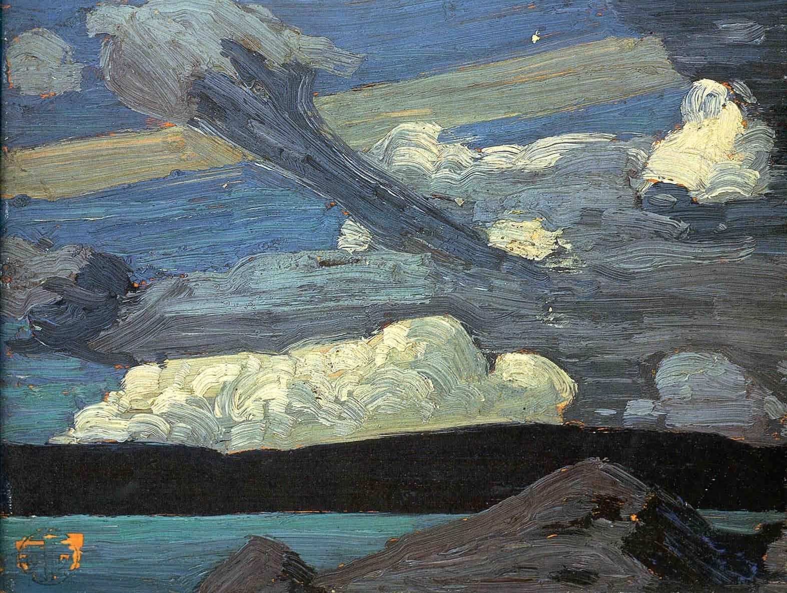
The Zeppelin-looking clouds certainly caught Tom's attention. These clouds hold the other secrets to be discovered clearly hidden within the brush strokes of Tom's weather observation.

Meteorologically I see a warm frontal zone and wind shear with obvious slantwise convection. The stronger winds in the warm air above the frontal surface must have a southerly component while the cold air beneath the frontal surface must have a northeasterly component. These wind patterns are part of the conveyor belt conceptual model in which a southerly flow of warm and moist air rises over a colder and drier air mass flooding in from the northeast. The southerly warm flow is called the “warm conveyor belt” - the large, red arrow labelled WCB in the accompanying graphic below. The northeasterly cold flow is called the “cold conveyor belt” - the narrow, blue arrow labelled CCB. Knowledge of this conceptual model allows one to decipher the seemingly complex patterns in a meteorological minute. We know exactly where Tom had to be when observing this weather - the yellow arrow.
 |
A parade of weather systems progressing across the Algonquin
landscape. The yellow arrow places Tom on the cold side of the
warm front looking southwesterly. The warm conveyor belt
(red WCB) directs turbulent warm and moist air above his location.
The cold conveyor belt (blue CCB) provides the chilly easterly
breeze that Tom was experiencing while he painted.
|
Let us examine each of the cloud signatures in turn.
 |
The cumulus cloud is lifted from the warm frontal surface and
ascends at an angle. The snowflakes fall into the
cold conveyor and are drifted with those easterly winds. |
Convective clouds that ascend on a slope require the momentum of the wind in the warm conveyor belt as well as some instability in the moist air mass to ascend. Meteorologists refer to this as Conditional Symmetric Instability (CSI). This convection on a slant is characteristic of the entrance region into the jet streak - a locally, stronger wind found along the larger-scale jet stream. The process is a challenging forecast that can lead to significant snowfall events.
The dull, grey cumulus cloud in the top left of the painting is just such an updraft ascending on an angle, riding an escalator to the northeast.
The small depth of the cumulus cloud is still apparently sufficient for precipitation processes. This tells us that the temperature regime in that cloud must be between minus 12 and minus 15 Celsius. At those temperatures, ice crystals grow most efficiently due to the high saturation vapour pressure over ice. The large dendritic flakes become heavy enough to fall at the leisurely rate of one metre per second. These flakes drift down directed toward the southwest by the cold conveyor belt. The large flakes gradually sublimate into water vapour within the cooler and drier air beneath the warm frontal surface.
It is not clear if a single flake ever made it to the ground as the virga trails into oblivion. A similar cloud and an identical process can be found in the left central portion of the painting. The snowflakes might take 30 minutes to reach the ground from the cloud base 5 or 6 thousand feet above the earth’s surface.
If we broaden our gaze, note that the whiter and lumpier clouds in the distance are more upright. Also, note how dark the cloud was beneath those cumulus congestus towers. It was snowing very hard under those white castles of clouds. This is the standard and more common form of vertical convection. Snow is certainly pounding down hard to the ground under these clouds.
The west-to-east, high-level band stretching across the top of the painting is another important piece of the puzzle. Notice that it is higher and behind all of the clouds in Tom's weather observation. It may resemble a contrail from a jet aircraft but that was quite impossible in 1915. This is “jet stream” cirrus cloud that can be found on the warm southern flank of the atmospheric current we now call the jet stream. In 1915 very few people even theorized that such a meteorological phenomenon existed. High-flying aircraft first confirmed this current of air during the Second World War.
 |
I back a jumbo jet up along the "contrail" in the PowerPoint
presentation accompanied by the roar of the jet.
That always got a laugh - so much fun! |
The jet stream is the high-level manifestation of the low-level contrast in temperature across the warm front. As a result, a jet stream will be found wherever you also have a frontal boundary. That cirrus cloud on the south and warm side of the jet stream is also referred to as "baroclinic zone cirrus" for this very reason.
Also, note the very sharp northern edge of the baroclinic zone cirrus. As I explained in "
A Jet Streak with a Paddle", this is characteristic of the entrance region to the jet streak. The deformation zone
must align with the flow in regions where the wind increases with speed. That is exactly the situation with the downstream jet streak that contains the strongest winds to be found along the jet stream.
 |
The jet stream is the result of the temperature contrast between
the warm and cold air masses. The surface front is the reflection
of that contrast at the ground. The speed of the jet stream
increases with the contrast of temperatures. |
All of these puzzle pieces fit very nicely with the cloud types, wind flows, convection types and precipitation. The strongest winds along this particular jet stream would be found near the “jet max” label on the painting. The meteorology might be subtle but Thomson clearly painted what he saw and nature is always right. Nature always makes sense unlike many things in our modern world.
 |
Another view of Tom's painting location with respect to the weather.
Tom was in the chilly easterly cold conveyor belt,
looking southwesterly at the warm frontal, convective cloud
while the jet stream passed overhead. |
Finally, the timing of this painting can be deduced by the illumination of the scene. It is certainly early evening with the moon rising in the east (left side of the painting) and brightly illuminating the northeastern flanks of the cumulus. The moon must be nearly full in order to result in so much brightness. This requires that the sun had set behind the western horizon (the right side of the painting) perhaps an hour or two previously as the sky was quite dark.
We can eliminate the possibility that the view was illuminated by the sun since the terrain was very dark with only the clouds illuminated. If this was sunlight passing through the long optical path of the atmosphere, Rayleigh scattering would insist on the light being tinted orange or red. The optical path of this light simply cannot be through an extended atmospheric path. Pure, reflected sunlight is quite “white” in nature.
The source of that white light must be quite high in the sky which could only be the full moon a couple of hours after sunset. Tom would have been enticed to include the spectacularly bright moon on the panel but that would have required an unrealistic adjustment to where those elements were in real life – something he would never do.
We can also eliminate a setting full moon since a waxing (increasing area of the moon illuminated by the sun) moon must rise in the east in the evening. We have already established that Tom was gazing southerly.
The colour and brightness of the clouds as Tom painted them, can also be explained. Large particles like snowflakes scatter much less light than small particles. This is because there is an order of magnitude fewer numbers of scatterers per volume when those particles are large. Vigorous convective cumulus clouds containing many, small liquid cloud droplets in their tops are excellent scatterers of light and are thus very bright. Research has found that these convective cloud tops are typically dominated by small, supercooled water droplets even in winter. This helps to explain why the vertical, towering cumulus clouds are brighter and whiter than the weaker cumulus clouds resulting from slantwise convection and conditional symmetric instability. Tom clearly painted exactly what he saw.
Now to better explain Conditional Symmetric Instability as this is key to understanding this weather that Tom painted!
 |
The Jet Streak Conceptual Model was produced by my friend and
colleague at COMET in Boulder, Colorado - Dr. James T. Moore |
This is the conceptual model of a classic jet streak. The low-pressure area and warm front that Tom painted would be located in the weak static stability, entrance region of this upper jet - the left half of this conceptual model. I am quite certain that Tom was not aware of this conceptual model when he completed the painting. This science was developed seventy years later more or less. Science was not even certain that a jet stream existed in 1915. Tom’s view would likely have been more southwesterly as compared to the southward pointing black and yellow arrow labelled as “Tom’s view” (a limitation of my graphic skills).
The energy gained from the atmosphere by warm air rising and cold air sinking is translated into the strongest winds of the jet core. The wind speeds decrease downstream from the jet core as this energy is spent to lift cold air and sink warm air like in an elevator. Conditional symmetric instability occurs in the entrance region of the jet core where the airflow is slanted like with an escalator. This further allows us to place Tom within this weather scenario. Everything is a balance in meteorology.
For meteorologists here is a short summary of the attributes of conditional symmetric instability (CSI).
Conditional symmetric instability is a:
- Cool season phenomenon
- Wind increases with height
- Strong baroclinic/frontal zone
- Air mass nearly saturated and is moist adiabatic
- Warm frontal location
- Large-scale forcing for lift
- CSI bands parallel to the thermal wind
For non-meteorologists, conditional symmetric instability (CSI) means that the clouds in advance of a warm front climb like on an escalator and can drop a lot of snow. The clouds closer to the warm front outside the CSI region, rise vertically in convective elevators and drop even more snow. If the temperatures in the snow-making region of the warm front are just right, large dendritic flakes are created by these convective clouds aligned along bands parallel to the upper-level front and the snow really piles up – often more than forecast.
The weather of Tom's observation was even more complicated than the astronomy that Tom included in his painting. Tom was certainly intrigued by the unusual cloud shapes and colours and was given the gift of inspiration in return.
 |
| #1266 "Tom's Zeppelins" |
In my colourful interpretation of "Clouds (The Zeppelins)" in support of the proposed "Tom Thomson Was A Weatherman" book, I just let the paint flow. On close examination, Tom's brush strokes were really fast and furious. It would have been dark as well and challenging to see even if he had the light of a kerosene lantern. I suspect he relied on the brightness of the full moon. His brush picked up paint from either side of his stroke and blended them together. There were really not many double strokes so the colours remained relatively unmixed. Tom was certainly not taking the time to polish the oils. Perhaps he could not see well enough to even discern a miss-stroke. That is the strength of a simple approach to plein air. Tom was very familiar with his colours and basic kit and the dim light was not a problem! Charge the scene and get it in oils before the inspiration is gone. There is no time for fixing any brush strokes. Paint what you see and do it quickly. The following is my plein air mantra.
- Load the brush;
- Drop the paint in one sweep;
- Move on;
- Have fun.
One stroke was enough for Tom and all that his panel received in the bright moonlight of that April evening. It would have also been chilly on his hands within the cold and damp conveyor belt blowing on his left shoulder. Chilly weather always makes me paint faster as well. In sharp contrast, I was comfortable in my Studio when I brushed in my version of "Tom's Zeppelins". The colours were very different in the computer image I referred to as I painted. As a result, I didn't worry much about matching the colours.
It was a good exercise to paint versions of each of Tom's paintings that I hoped to use in my book. It really forced me to examine each stroke and discern more clues clearly hidden in plain sight. I discovered another more subtle example of conditional symmetric instability (CSI) on the left edge of the painting.
I even painted "Rigel" in the spot it would appear if there were no clouds. Tom had included a fleck of white paint in about the same spot but a bit lower. It made me wonder whether he played the same joke and laid the star on top of the transient cloud that would have occasionally moved out of the way. This fleck of white paint on top of the cloud is possible especially if Tom's sense of humour was like mine.
The other possibility was that Tom actually intended to include Rigel as he witnessed it between the clouds getting in the way. If so, Tom misplaced Rigel in relation to the other three stars. That error could be explained by a time difference in the observation of Rigel or it could be simply a slight misplacement. No one will ever know for certain.

As was customary for Tom, he did not even take the time to sign this observation of the stars and the weather. The blunt force of applying the estate stamp eventually caused some paint to flake from the wooden panel. If only Tom would have taken a few more moments to scratch his name in the wet oils. It would have also been helpful if he had explained a bit more about his motivation to record this skyscape.
Creative Scene Investigation is an iterative puzzle. You need to take a chance and place a few puzzle pieces even if you are not certain what the image looks like. Eventually, you discover the picture by fitting in as many puzzle pieces as possible even if it means rearranging those first guesses several times. One must keep an open mind to the multiple possibilities in order to discover and construct the truth.
I do hope that these posts assist you in better understanding and appreciating the genius of Tom Thomson. This is the closest that we might get to actually looking over Tom's shoulder as he painted in natural wonder before the moonlit night sky of April 29th, 1915.
Warmest regards and keep your paddle in the water,
Phil Chadwick
PS: I have presented this material many times including to some very highly qualified professors of meteorology at COMET and UCAR in Boulder, Colorado as well as within Environment Canada. There was a strong consensus in the conclusions reached. The presentation and sound effects especially with "Clouds (The Zeppelins)" received a lot of laughs. Art and science can indeed be the same thing and a dash of humour helps them both.


No comments:
Post a Comment